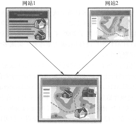
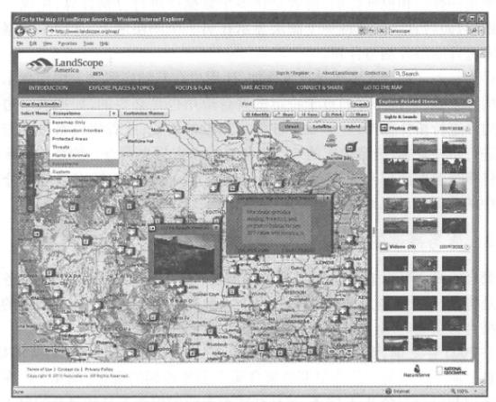
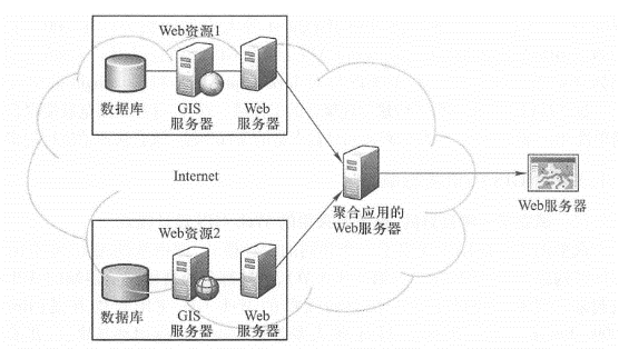
The word “aggregation” originated from popular music and is commonly known as mix, platter or joint singing. It is the mixing or splicing of multiple songs to create a new song. After 2005, aggregation took on a new meaning. The explosive growth of World Wide Web content has not only laid the foundation for resources needed for aggregation, but also created the demand for aggregation applications. The charm of the World Wide Web has attracted the active participation of governments, businesses, institutions and the majority of Internet users. Web services, web pages, blogs, photos and video resources on the World Wide Web are constantly updated and increased. However, the organization and presentation of these content and functions cannot meet the needs of all users. Users often need information from multiple websites, which creates the need to combine (i.e., aggregate) the content of multiple websites in one application (Figure 4.1). 图4.1聚合将多个网站的内容和功能动态地组合起来,生成新的应用 Here are a few examples of aggregation applications: Websites such as BizRate and PriceGrabber extract price information for items from multiple retail websites and organize them on one page, allowing buyers to find the best deals on one website without You must visit multiple websites separately. The HousingMaps website ( http://www.housingmaps.com ) combines home sales information from Craigslist with maps from Google to allow users to see at a glance where homes are sold, their geographical location and surrounding environment. Zillow website ( http://www . zillow. com) Estimate the value of a home and superimpose it on Microsoft Bing Maps to display home prices, area, property taxes, school district and other relevant information. The CrimeMapping website (www.crimemapping.com) displays crime data on ArcGIS Online maps to provide the public with information on community criminal activities. The Stimulus Tracker website ( http://www.Oregon.gov/recovery/StimulusReporting/ARRA_Projects.shtml ) in Oregon, USA superimposes the units and locations where funds were received in the national economic stimulus plan with a map from ArcGIS Online to inform the public of where funds were distributed and the share data received by each department. The public information map website ( http://tmapps.esri.com/TIM/index.html ) locates and displays people’s tweets posted on Twitter, videos posted on YouTube, and photos posted on Flickr on ArcGIS Online maps, so that users can understand what netizens in a certain area are talking about and what they see and hear. Thousands of map applications registered on ArcGIS.com combine ArcGIS Online basic basemaps with user-published geographic information Web services for various topics. The LandScope America website ( http://www.landscope.org/map ), jointly developed by NatureServe and National Geographic, combines Microsoft Bing Maps with nature conservation maps and aggregates a large number of photos, audio and video clips about plants, animals and the natural environment (Figure 4.2). Figure 4.2 The LandScope America website ( http://www.landscope.org/map ) is an example of an aggregation application. It integrates NatureServe’s nature conservation map layers, rich multimedia data on the MetaLens website, and Microsoft Bing Maps to provide online resources related to nature conservation. (Thanks:NatureServe, Microsoft and National Geographic) From these examples, we can see the definition of aggregation: aggregation is a development method that creates new web pages or new applications by dynamically combining resources from multiple websites. This definition has three main points: Web Resources: The Web resources used to build aggregations can be content (such as data and maps) or functions (such as operations or processes). For example, analytical Web services usually encapsulate certain types of business logic, and the Web service can return the business logic (including its functions, and Not just the content). Dynamic: This means that there is a dynamic connection between a converged application and the resources it uses. If the information source is updated, the syndication application will automatically update it immediately or within an appropriate time. Multiple websites: One website can be the aggregation application itself. If you superimpose your pictures on another site map on your website, your website is an aggregation application. Based on the previous definition of aggregation, a geographical aggregation is an aggregation that contains at least one geographical content or function. Geographical aggregation integrates multiple data sources with the same geographical location, which obviously contains the core concept of “overlay” of geographical information systems. Superimposition is often vividly used as a “sandwich cake”(Figure 1.4). Such illustrations often appear on the covers of GIS textbooks or on the icons of GIS institutions. Overlay includes topological overlay and visual overlay. The former divides multiple data layers and generates a new data layer; the latter just displays one layer on top of another layer. There is no graphic segmentation and merging between the two data layers. Most current geographical aggregations are visual overlays, allowing users to add and display some thematic information on top of the basic basemap. Of course, topological superposition is also necessary for specific aggregation applications, such as topologically superimposing flood boundaries and city boundaries to calculate the area of the city submerged by floods; or topologically superimposing flood boundaries and cadastral layers to determine whose property needs to be conducted. Flood damage surveys are needed. Traditional GIS overlay requires multiple data layers to be pre-stored on a local computer, while aggregation can directly read data distributed on the Web and dynamically overlay it. The concept of aggregation dates back to the emergence of Web services. The intention of people to study and develop Web services is to use Web services as programming components, allowing developers to combine Web services on one or more servers into new applications. This is actually what we call aggregation today. Before 2005, aggregation was advocated by some software vendors, government departments and research institutions and was a top-down behavior. These early aggregations were server-side aggregations (Figure 4. 3)Calling and combining multiple Web services on the server side often requires professional programming tools and complex server-side programming development, and involves more complex server-side deployment, which requires a lot of work. Therefore, server-side aggregation is mainly limited to professional programmers. Because Web services at that time were not as abundant as they are now,”a clever woman cannot cook without rice”, aggregation did not immediately become popular. Still, these related concepts and technologies laid the foundation for the subsequent prosperity of geographical aggregation. Fig. 42 In the server-side aggregation architecture, the aggregation server issues requests to different Web resources, receives service responses, and consolidates the results. This was the main form of aggregation before the advent of browser-side APIs and is still suitable for certain situations # Current aggregation is mainly done on the client side, especially on the browser side (Figure 4.4). Browser-side aggregation is grassroots. In 2005, many online maps provided maps through JavaScript and AJAX (Asynchronous JavaScript and XML) technology. Internet users could use a browser to view their source code. Some developers cracked the source code of these online maps and built aggregation applications such as marking houses on maps. Noting the number of users aggregated apps can attract and their huge advertising potential, Fig. 43 In a browser-side converged architecture, the browser issues requests to different servers, receives service responses, and then synthesizes and displays the results. Such aggregations usually use lightweight programming, are easy to develop applications, and have become the most dominant form of aggregation since 2005 # Popular map service providers such as Google, Microsoft, Yahoo and MapQuest released their JavaScript AWs in 2005 and 2006. Professional GIS companies have also adopted this technology. For example,Esri has successively released ArcGIS programming interfaces for JavaScript, Flex, and Silverlight. These interfaces significantly reduce the effort involved in building geographical aggregations. In this way, syndication quickly became popular thanks to the simplicity of browser-side syndication, vendor support, public interest, and increasingly rich Web services. A good and universally adopted WebGIS design model has been established Many aggregation applications show a common design pattern, which is an optimization pattern composed of basic basemaps, business layers, and tasks (see Section 2. 3. Section 3), these parts are usually integrated using browser-side APIs. This model provides a quick and simple solution to build WebGIS applications (Brown 9;Brown et al., 2008)。At present, most WebGIS applications are aggregation and adopt this design pattern. Promote the popularization of WebGIS application development The aggregation approach is a milestone that expands GIS application development from professionals to more people, with low technical requirements for developers. The simplicity of aggregation encourages active participation by the public, provides them with a platform to demonstrate their creativity, and promotes the development of “new geography” and spontaneous geographical information. Syndication apps can display family photos, celebrities admired by personalities, ball games, Olympic torch relay, auctions, webcams, Weibo and news events on a map. Although many aggregation applications do not have a clear business purpose and are made purely for fun, they demonstrate a wide range of applications for GIS. The World Wide Web as your database and GIS server John Gage of Sun Microsystems put forward the famous saying that “a network is a computer” in 1984, envisioning that a single computer in the future will be able to use resources distributed throughout the network to expand storage capabilities and improve computing performance, thereby surpassing the capabilities of a single computer. Convergence takes us one step closer to this idea. Many units or projects do not have their own databases and servers due to lack of funds, but they can use aggregation architecture to obtain the data, maps, and analytical models they need from the Web. Traditional GIS application development often starts by collecting or purchasing data yourself. Today’s GIS applications basically no longer need to collect or purchase basic basemaps. Instead, they use free basemaps on the Internet. Even thematic layers can be found online. Aggregation can use Web resources with formal programming interfaces or resources without formal programming interfaces, such as HTML pages and photos. These resources contain a large amount of valuable geographical information, which will have great application potential if they can be extracted and used for aggregation.Reorganization of Web resources #
Server-side aggregation and client-side aggregation #
Important impact on GIS #