Internet and GIS #
Undoubtedly, the development of the Internet has brought great convenience to the development of GIS, while also providing new fields for GIS theory and technology research. As an information system and a discipline, GIS can be mainly influenced by the development of the Internet in the following aspects:
GIS researchers use newsgroups or email to explore GIS technology issues.
Online distance education refers to the practice of professors placing lesson plans in the form of HTML documents online for students to download and use, and allowing them to ask questions via email, thus creating a ‘Virtual University’. GIS education can also be conducted in this way. Currently, there are GIS education websites available http://giswww.kingston.ac.uk Provided three topics related to GIS; URL http://www.utexas.edu Introduced the challenges faced by GIS and geography teaching, there are many Q&A questions about common GIS issues website http://www.census.gov/pub/geo/gis-faq.txt .
The download of GIS software allows GIS software companies to regularly post the latest versions of their developed software on their sites for users to download and try.
Some of the URLs listed in this article are highly likely to have become ‘invalid’ by the time readers see them, which is almost a common occurrence on the web.
Introduction to WWW URLs in Typical Geographic Information Systems [Gong Peng]
(1) GIS WORLD INC. *http://www.gisworld.com*
Geographic Information Systems World is currently the best-selling magazine in the field of GIS internationally. Its website lists the content catalog of any issue published by the company, and users can also use a search engine to search for content.
(2) GIS software developer website
ESRI Corporation ( http://www.esri.com ), Intergraph Corporation ( http://www.intergraph.com ), MapInfo Company( http://www.mapinfo.com ).
These are considered top-notch GIS websites with rich GIS information, including company introduction, products, company publications, annual reports, conference forecasts, user information, product ordering, technical consulting, programming skills, employment opportunities, product displays, and free software downloads, among others.
(3) Virtual Traveler Network* http://www.vtouris.com *
This website allows users to interact with map displays, starting with world maps, followed by maps of various countries or regions, and finally city maps. Its map is a grid image that utilizes spatial location for user interaction operations, with a large amount of descriptive information such as text and images available for users to refer to.
(4) Canadian Earth Information Science Network* http://abbott.ccm.emr.ca *
This website is a national level organization that manages Earth information and provides a wide range of products and services, including satellite images of Canada, national atlas data, Canadian place names database, terrain database, road network, digital terrain data, and more. In addition, it also provides services to obtain the above data, using a search engine to obtain data for the search area.
(5) Fill in Data Query and Expression URL* http://tiger.census.gov/cgi-bin/mapbrowse-tbl *
This website uses fill in the blanks for querying. It provides a table where users fill in relevant information and then pass the request to server-side GIS, mapping, database query and other software to run corresponding searches and queries. It can also be spatial analysis, and the results can be maps or tables, which are then transmitted back to the browser. Microsoft’s portal site MSN also provides similar functionality http://msn.maps.expedia.com/quickmaps.asp .
(6) GIS Forum *http://gis.itc.nrcs.usda.gov/gishome.html*
This website includes the release of GIS data and software, events in the GIS field, discussions on some technical issues, introductions to GIS books, and more. In addition, discussions on related issues can be conducted through email.
4)空间数据发布和下载,数据是GIS系统中最为重要的部分,数据的录入和预处理也是GIS应用开发过程中耗费时间、资金最多的一个环节,而通过因特网实现数据共享,可以降低GIS工程的开发成本。由于因特网的迅速发展,促进了电子商务的兴起,空间数据当然也可以作为一种特殊的商品在因特网上发售。与后面提及的WebGIS方式相比,这里的数据下载还主要是利用文件传输的方式实现。由于因特网上信息量浩大,常常使得找到真正需要的数据成为一件困难的事情,而应用空间元数据可以使用户迅速定位需要的数据并进行下载。1994年美国政府开始发展国家空间数据基础设施( NSDI ),通过确定元数据标准,要求各级政府机构采用元数据的方式在网络上对其所生产的数据进行描述,达到各机构间数据生产和共享的目的。
5)此外,由于因特网的发展,打破了传统的时间——空间联系方式,形成了空间事物的新的组织形式,称为计算机网络信息空间(CyberSpace),是目前人文地理学研究中的热点,也将是GIS探讨的重要课题。
Introduction to WebGIS #
The most exciting product of the combination of web technology and GIS technology is WebGIS (World Wide Web Geographic Information System). WebGIS, In short, it is a new technology that utilizes web technology to expand and improve geographic information systems. Due to the client/server based request/response mechanism adopted by the HTTP protocol, it has strong user interaction capabilities and can transmit and display multimedia data on the browser. The information in GIS mainly needs to be represented in the form of graphics and images, and users can query and analyze spatial data through interactive operations. These characteristics enable people to fully utilize the Web to search for the spatial data they need and perform various operations. Specifically, the application of WebGIS can be divided into the following levels:
1) Space data release
Due to its ability to display spatial data in graphical form, WebGIS makes it easier for users to find the data they need compared to simple FTP methods;
2) Spatial query and retrieval
Utilize the interactive capabilities provided by the browser to query and retrieve graphics and attribute databases;
3) Space Model Service
Provide implementation methods for various spatial models on the server side, receive model parameters input by users through a browser, and return the calculation results. In other words, using the Web can not only publish spatial data, but also publish spatial model services, forming a Browser/Server (B/S) structure.
4) Organization of Web Resources
On the Web, there is a large amount of information, most of which have spatial distribution characteristics. For example, distributor data often has its location attributes. By using maps to organize and manage this information, and providing users with spatially based retrieval services, it can undoubtedly also be achieved through WebGIS.
Compared with traditional geographic information systems, WebGIS has its own unique features, mainly manifested in:
It must be a network-based client/server system, while traditional GIS is mostly an independent standalone system;
It utilizes the Internet for information exchange between clients and servers, which means that the transmission of information is global;
It is a distributed system where users and servers can be distributed across different locations and computer platforms.
Implementation Technology of WebGIS #
WebGIS is an important component of network GIS. Some concepts of network GIS, such as client/server mode, distributed data management, etc., can also be applied to WebGIS. However, when implementing WebGIS, two issues need to be considered: controlling the amount of data transmitted over the network and the need to interact with users through a browser.
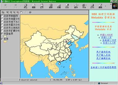
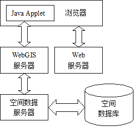
At present, various technical methods have been applied to the development and implementation of WebGIS, including CGI (Common Gateway Interface) method, Server API method, Plug ins method, JavaApplet method, ActiveX method, and so on. Below is a brief description and comparison of these technologies. [Xia Fuxiang] CGI is a specific standard used between web servers and client browsers, which allows web users to launch a program (called CGI program) that exists on the web server host through commands on the web page, and receive the output results of this program. CGI is the earliest technology to implement dynamic web pages, which allows users to interact through a browser and obtain corresponding operation results. CGI can generate images and then pass them to the client browser (currently, most homepage visitor counters are implemented using CGI programs). In theory, any GIS software can be connected to the Web through CGI. Remote users can make requests through a browser, and the server passes the requests to the backend GIS software. The GIS software generates a digital image as required and sends it back to the remote user. In fact, due to design reasons, most GIS software cannot be directly connected to the Web as CGI programs, but there are two techniques that are relatively successful. 1)用CGI启动后端的批处理制图软件,这种软件的特点是用户可以直接在计算机终端一行一行地输入指令来制图。其特点是用户的每一个要求都要启动相应的GIS软件,如果软件较大,启动时间就会很长。 2)CGI启动后端视窗(Windows)GIS软件,CGI和后端GIS软件的信息交换是通过“进程间通讯协议(IPC-InterProcess Communication)”来完成,常用的IPC有RPC(Remote Procedure Call)和DDE(Dynamic Data Exchange)。其优点在于,由于GIS软件是消息驱动的,CGI只要通过发送消息,驱动GIS软件执行特定操作即可,不需要每次重新启动。 The Server API is similar to CGI, but the difference is that CGI programs are standalone programs that can run, while the Server API often depends on specific web servers, such as Microsoft ISAPI depending on IIS (Internet Information Server), which can only run on the Windows platform and has poor portability. However, the Server API will remain running after startup, and its speed is faster than CGI. By using CGI or Server API, although the interactivity of the client is enhanced, the information obtained by the user is still static. Users cannot manipulate individual geographic entities or quickly zoom in and out of maps because on the client side, the entire map is a single entity, and any GIS operations such as zooming in, out, roaming, etc. need to be completed by the server and the results returned. When the network traffic is high, the system response slows down. One solution to this problem is to use plugin technology. Browser plugins refer to software that can exchange information with browsers, and third-party software developers can develop plugins to enable browsers to support data files in their specific formats. By using browser plugins, some server functions can be transferred to the client. In addition, for WebGIS, plugins process and transmit vector format spatial data, which has a small amount of data. This accelerates the response speed of user operations, reduces network traffic and server load. The drawback of plugins is that, like traditional application software, they need to be installed before they can be used, which creates inconvenience for users. The following is an example of using a WebGIS plugin to display spatial data on the Internet. With the plugin, it is easy to navigate, zoom, and query maps. Fig. 211 WebGIS plugin, from Peking University Digital Earth Studio ( HTTP://WWW.CYBERGIS.ORG.CN ) # The WebGIS plugin can effectively process spatial data together with the browser, but its obvious drawback is that the computation is centralized on the client side, known as the “fat client”, while for CGI and Server API methods, data processing is done on the server side, forming a “thin client”. The use of Java language can compensate for the shortcomings of many traditional methods. Java language is an object-oriented language, and its biggest advantage is the slogan “Write once, run anywhere” proposed by SUN company, which refers to its cross platform feature. In addition, Java language itself supports exception handling, networking, multithreading and other features. Its reliability and security make it an important programming language on the Internet. After compilation, the Java language generates platform independent bytecode that can be interpreted and executed by Java Virtual Machines (JVMs) on different platforms. There are two types of Java programs, one can run independently, and the other is called JavaApplet, which can only be embedded in HTML files and interpreted and executed by browsers. The advantages of using JavaApplet to implement WebGIS over plugin methods are: 1) At runtime, the Applet downloads from the server without the need for software installation; 2) Due to the support of network functionality in the Java language, direct connection between Applets and server programs can be achieved, allowing data processing operations to be implemented both on the server and on the client side, achieving load balancing on both ends. Figure 13-16 shows the architecture of a WebGIS system implemented using JavaApplet. Fig. 212 A WebGIS System Framework Implemented with Java Applet # Another technology that can implement WebGIS is ActiveX, which is a new Internet technology developed on the basis of Microsoft’s OLE technology. Its foundation is DCOM (Distributed Component Object Model), which is not a computer language but a technical standard. Components developed based on this standard are called ActiveX controls, which can be embedded into HTML files like JavaApplets and run on the Internet. Compared with JavaApplet, its disadvantage is that it can only run on the MS Windows platform, and due to its ability to perform disk operations, its security is poor. However, its advantage is fast execution speed. In addition, due to the fact that ActiveX controls can be implemented in multiple languages, the original GIS software source code can be reused, which improves software development efficiency. The above describes several implementation schemes for WebGIS. In actual system construction, different schemes can be adopted and corresponding software can be selected based on the data volume, data type, web server software, client requirements, etc. of the data to be published. Table 13-7: Several important features of WebGIS technology abroad [Song Guanfu et al.] MapInfo ProServer GeoMedia Web Map Internet Map Server(IMS) MapGuide ModelServer/ Discovery Company MapInfo Corp. Intergraph Corp. ESRI Inc. Autodesk Inc. Bently Server operating system Windows NT/95 Windows NT Windows NT Windows NT Windows NT Web server Web Server supporting CGI Internet Information Server Internet Information Server or Netscape Server Web Server supporting CGI Netscape Server Other server-side software ODBC, MapInfo 4.x, MapBasic ODBC ArcView or MapObjects applications ODBC ODBC MicroStation GeoGraphics ODBC Client operating system Windows series Macintosh、UNIX Windows NT/95 Windows series Macintosh、UNIX Windows NT/95 Windows series Macintosh、UNIX Client browser Any browser that supports HTML Internet Explorer, Netscape Navigator Any browser that supports HTML Internet Explorer ,Netscape Navigator Internet Explorer, Netscape Navigator Does the client require plugins/controls No need If using Netscape Navigator browser, the ActiveCGM plugin needs to be installed; If using Internet Explorer browser, the ActiveCGM control will be automatically downloaded Automatically download Java Applet or ActiveX controls Need to install MapGuide plugin (about 1 MB) Need to install plugins such as VRML, CGM, SVF, etc Graphic format transmitted over the network ActiveCGM (raster and vector graphics) ActiveCGM (raster and vector graphics) JPEG/GIF (raster image) MWF (Vector Graph) JPEG, PNG, VRML, CGM, SVF (raster and vector graphics) Map pre publishing processing Dynamically generate maps Dynamically generate maps Dynamically generate maps Map pre publishing processing is required Dynamically generate maps Data formats that can be published MapInfo map file MGE engineering, MicroStation DGN files, FRAME files, MGEDM files, ArcView Shape files, Arc/Info Coverage, SDO files ArcView Shape file, Arc/Info Coverage, SDE map file, Autodesk DWG file Autodesk DWG GeoGraphics engineering files, MicroStation design files</TBODY> At present, in the field of WWW, extensible markup language (XML) has received increasing attention. It can become a “meta language” used to define markup languages for specific domains. Similarly, in the Internet publishing of spatial information, XML can also be used to define specific language tags for geographic information, formatting and transmitting data in an easy and consistent manner.CGI method #
Server API method #
Plugin method #
Java Applet Method #
ActiveX method #