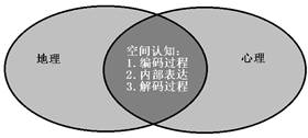
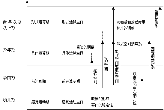
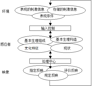
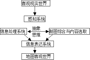
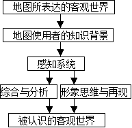
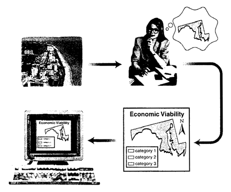
The geographical environment is inherently complex and diverse. To accurately understand, master, and utilize such extensive and intricate information, it requires a refining process that separates the essential from the non-essential and distinguishes truth from falsehood. This necessitates a scientific approach to comprehending the geographical environment. Understanding such complex entities involves an abstract process that progresses from perceptual to rational cognition. When different social sectors or academic disciplines observe the same objective world, they often focus on distinct issues and research subjects, leading to the formation of varied environmental perceptions. Cognition falls within the domain of psychology. Cognitive theory was introduced into cartography as early as the 1970s, employing a “stimulus-response” relational model to study the psycho-physical reactions of map users during map reading. The research on cartographic visualization, which emerged in the 1990s, also applied cognitive concepts, advancing the study of the “stimulus-response” model to greater depth. The essence of cartographic visualization lies in exploring human understanding of spatial objects within the map information transmission process. To meet the demands of spatial information analysis and visualization, cognition should be regarded as an integrated information processing system encompassing perception, attention, mental imagery, memory, learning, reasoning, language, concept formation, problem-solving, emotion, and individual differences. In a simplified cognitive system, the perceptual system receives stimuli from the external environment, processes them through transformation and integration, extracts distinctive features for recombination, and ultimately outputs encoded physical stimuli. The long-term memory system then compares these encoded inputs with internally stored information through pattern matching, leading to the activation of specific memory traces. These activated elements are subsequently transferred to the working memory system, where limited information undergoes elaborate processing before being channeled through the response system to manifest as actions, speech, and expressions. Overseeing this entire framework is the central processor, which controls system operations, determines goal priorities, and monitors ongoing task execution. Figure 2-2 illustrates this architectural framework of spatial cognition. Fig. 12 Spatial cognition # Spatial cognition Geographers and psychologists have conducted extensive research on space, yielding numerous insightful conclusions that form the foundation for studying human spatial decision-making in behavioral geography. Investigating spatial cognition within GIS can guide the development of spatial models and information representation methods that better align with human thought processes. The following section introduces knowledge related to spatial cognition. 1) Formation and development of individual spatial cognition J.Piaget认为,空间认识具有四个层次: The sensorimotor stage, which is founded upon action schemas; The pre-operational stage, which is grounded in mental imagery of the objective world retrieved from memory; The concrete operational stage, which permits the formation of symbolic and systematic mental representations of the environment; The formal operational stage, wherein individuals possess hypothetical-deductive reasoning capabilities and can process abstract spatial concepts independent of actions, objects, or concrete space. Figure 2-3 illustrates the development of spatial cognition throughout an individual’s growth process. Fig. 13 Individual development of spatial awareness # 2) Spatial information coding in consciousness [Elisabeth S. Nelson] Regarding the encoding methods of spatial information in individual consciousness, there are three primary theories: Propositional Theory, Imagery Theory, and Dual-coding Theory. A proposition is a conceptual structure that expresses relationships between objects. It must adhere to the following rules: it must be abstract, associated with a truth value, and conform to specific formal rules. According to Propositional Theory, spatial encoding takes the form of simple statements such as “Oklahoma is north of Texas.” The key tenet of Propositional Theory is that such propositions encode abstract meaning rather than preserving the perceptual characteristics of the original information. The so-called Imagery Theory posits that mental imagery constitutes the fundamental component of spatial cognition. Grounded in a pictorial metaphor, this theory suggests that individuals perceive and process spatial information, then organize it into simplified and more structured forms. This processed information is stored in memory and can be subsequently retrieved and reconstructed into mental images when needed. According to Dual-Coding Theory, linguistic and visual information undergo independent processing while maintaining interconnectedness between their respective cognitive systems. The imagery system organizes elementary visual components into hierarchical structures capable of spatial manifestation, whereas the verbal system concurrently processes non-visual information by integrating it into higher-order sequential architectures. Geographic information system is information processing system, that is, input information, encode, store memory, make decisions and output results. This is why the process of environmental information flow in the human brain is simulated and replicated by GIS. Of course, the purpose of cognition is to solve problems, that is, to find solutions to problems. Cognitive operations include conventional problem solving and creative problem solving. An environmental image can be regarded as an acquired and stable mental construct that synthesizes an individual’s understanding, evaluation, and decision-making capacity regarding their surroundings. For any investigation concerning human-environment interactions, understanding what types of information the brain processes and utilizes is of critical importance. The dynamic relationship between humans and their environment is illustrated in :numref`人与环境的相互作用关系图` . Fig. 14 Diagram of the interaction between human beings and the environment # In environmental image research, how can meaningful information about large-scale environments be extracted from individuals? How can this information be represented to clarify the scope and depth of personal cognition? And how should such information be analyzed? The most prevalent methodology involves having subjects draw sketch maps depicting environmental elements. These sketches provide data by revealing the sequence of environmental components, the connections and distinctions between elements, types of mental imagery, and variations in detail and scale, essentially constructing a cognitive model. In scientific research, models are frequently employed as substitutes or simulations of real-world entities. These models maintain specific degrees of consistency or similarity mapping relationships with the studied objects. Consequently, conclusions and inferences derived through these models can be effectively transferred and applied to the actual subjects of study. The representation models employed in geography are remarkably diverse, encompassing various forms such as cartographic maps, aerial and satellite remote sensing imagery, statistical charts, and cross-sectional diagrams. Among these, maps stand out as the most universally utilized and critically important model within the geosciences. From the perspective of model characteristics and essence, maps serve as visual/symbolic/generalized models of the objective world. Individual map sheets function as models simulating specific aspects of reality, while map series and atlases constitute higher-level models representing geographic systems. These advanced models simulate the integration of natural and socio-economic elements, revealing their interconnections, interactions, analytical characteristics and synthesized effects, current states and future trajectories, along with the functional attributes of the complex macro-systems they collectively form. Map cognitive model can be divided into the cognitive model of map compiler and designer and the cognitive model of map user (Figure 2-5 and Figure 2-6)。 Fig. 15 Map compiler’s cognitive model # Fig. 16 Map user’s cognitive model # The cartographer’s cognitive model emphasizes the comprehension of both the geographic phenomena being represented and the expressive forms through which they are visualized. The fundamental purpose of this cognitive framework is to guide mapmakers in selecting the most essential content and optimal visualization methods, thereby enabling efficient transmission of spatial information (Figure 2-7). The map user’s cognition builds upon existing cartographic representations while integrating their personal spatial knowledge and background, ultimately achieving comprehension of the mapped content and thereby indirectly attaining understanding of the objective world. Fig. 17 Mapping activity process # Geographic cognition is a subsystem in the process of geographic information transmission. It focuses on psychological perception and analysis. Cognitors not only perceive the obvious information on the map but also excavate the potential information. They not only detect, identify or distinguish information, but also actively interpret information to form an overall understanding of the objective world. From the geographic cognition of cartographers when compiling maps to the geographic cognition of users when reading maps, the whole process reflects the characteristics of people’s understanding of geographical topics from shallow to deep. Because the transmission process of geographic information from original cartographic data to maps and then to new maps is exactly the spiral ascending process of people’s cognitive depth of geographic things. Geographic cognition is not only the basis of geographical model, but also the basis of cartographic generalization. On the basis of geographic cognition, the real world information is abstracted and generalized to form a model in geographic information system, which shows the classification, classification and spatial pattern of geographic elements in a certain scale. Map model itself is a process of unity of subjectivity and objectivity. GIS experts not only comprehensively and comprehensively analyze and understand the geographical environment, but also include acceptance or recognition of some objective simulation standards and norms. In addition, geographical cognition runs through the whole process of cartographic generalization. Specifically, it manifests itself in the stage of map design. It is guided by the knowledge of the system function, hierarchical structure and the combination of various elements of geographical environment acquired from geographical cognition on the concept of generalization principles, contents, classification and grading indicators of cartography. In the stage of map compilation, when dealing with the elements or figures that meet the generalization criteria, we can further understand the control and guidance role of geo-cognition in the selection of map elements, the generalization of quantity and quality, and the simplification of graphics, so that we can have a good idea of the control and guidance of geo-cognition, and operate correctly, so as not to misunderstand the generalization criteria and rules. The primary distinction and advantage of maps compared to other geoscientific models lie in their visual nature, enabling complete, clear, and intuitive graphical representation and explanation of real-world entities. “A map serves as a visual graphic representation of spatial relationships and spatial forms on the Earth’s surface.” A further distinguishing feature of maps compared to other graphic models is their utilization of specially designed and predetermined symbols to represent features, phenomena, and geographic processes, while simultaneously indicating their spatial positions, qualitative attributes, and quantitative characteristics. The combination of various symbols constitutes distinct cartographic representations, and the integration of these representations forms a complete map graphic. The function of map symbols extends far beyond mere information transmission; they also serve as powerful tools for recording knowledge, solidifying understanding, and systematizing geographic expertise. Map is not a complete reproduction of objective objects, but a model which is “filtered”, generalized and abstracted by the brain and hands of the cartographers. It is the result of a series of complicated scientific thinking and creative work for cartographers to comprehend, synthetically analyze and abstractly generalize the features, such as choosing or rejecting them, simplifying graphics, generalizing quantity and quality, coordinating them, and exaggerating them. Therefore, map generalization of cartographic objects is one of the most important features of maps as an objective and practical model.The Meaning of cognition #
Environmental mapping and model #
Map cognitive model #
Scientific cognition of geographical objects #
Map is the Image of the Objective World-Symbol-Summary Model #
Map is the image model of the objective world #
Map is the Symbolic Model of the Object World #
Map is a generalized model of the objective world #