With the development of GIS technology, especially the application of network technology in the construction of GIS, standardization related to it has become a problem that must be solved. A good standard is an indispensable part of promoting, guiding and ensuring efficient and high-quality geographic information exchange.
In the field of information technology, standards and specifications can be divided into two types based on their usage status, namely actual standards and legal standards.
The former is a widely accepted standard developed by institutions, groups, and organizations through continuous practice, such as TCP/IP protocol and OpenGIS specification;
The latter is usually established through legal standards for policy or management purposes, such as the spatial metadata content standards developed by FGDC.
According to the size of the jurisdiction, standardization organizations for information technology can be divided into five levels (Cargill), namely:
International standardization organizations, such as ISO;
Regional standardization organizations;
National standardization organizations, such as the American National Standards Institute (ANSI) and the Federal Geographic Data Committee (BGD);
Government and user level standardization organizations, in the field of GIS, OGC (OpenGIS) belongs to this level;
And supplementary standardization organizations.
At present, in China, the GB series of standards related to GIS mainly include some geographic coding standards, including:
GB2260-80 “Administrative Division Code of the People’s Republic of China”,
GB/T13923-92 “Classification and Code of Basic Land Information Data”,
GB14804-93 “Classification and Codes of Elements for 1:500, 1:1000, 1:2000 Topographic Maps”,
GB/T5660-1995 Classification and coding of topographic map elements for 1:5000, 1:10000, 1:25000, 1:100000, etc.
Generally, the standards and norms of information technology can be divided into the following five aspects:
Standards for Hardware Equipment. In network technology, there are a large number of such standards, such as the IEEE 802 series;
Software standards. Including operating system, query language, programming language, graphical user interface and so on, such as SQL, DCOM, CORBA, etc;
Standards of data and format. It includes data model, database construction, data quality and reliability, classification system of geographical elements, data format conversion, etc. In the application of geographic information, spatial data coding standards, metadata standards and so on belong to this category;
Data set standards. Data storage file format standards, such as the U.S. Census Bureau’s TIGER file standards;
Process Standards. For example, ISO9000 series and CMM are mainly for the guidance of system development process。
The standardization of geographic information systems mainly includes the standards in the last four aspects, including:
Software tools, such as documentation, design, acceptance, evaluation standards, and software interface specifications;
Data, including data models, data quality, data products, data exchange, data display, spatial coordinate projection, etc;
System development, system design process, data process flow, standard library construction process, etc;
Other, including terminology, management methods, etc.
Generally speaking, standards for software tools, system development, management methods, and other aspects can be borrowed from more general information technology standards and specifications, so GIS standards mainly focus on spatial data and a series of related specifications.
The application of GIS standards can establish a more standardized data input and processing, the aim is to improve work efficiency and quality, and use consistent data format and spatial data visualization to guide the use of data.
In a word, introducing a series of standards into geographic information system is conducive to ensuring the standardized development of geographic information system technology and its application, guiding relevant practice activities of geographic information system, expanding the application fields of geographic information system, and thus realizing the social and economic value of geographic information system. Based on the geographic information system standard, the sharing and interoperability of geographic information in different application areas can be realized, which is one of the key technologies to realize the digital earth (Figure 17-1). Fig. 257 Significance of geographic information standards for geographic information system applications # 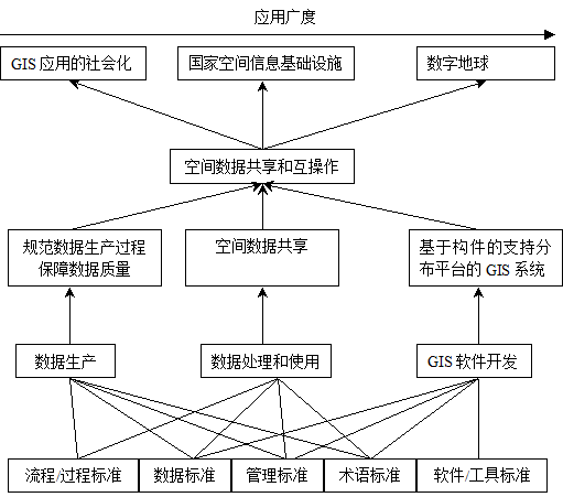
Standard formulation process of ISO: [Cargill]
The formulation process of ISO standards is mainly divided into the following steps:
Because of the subcommittees draft new work content plans, it needs to submit them to a technical committee for a vote;
After the voting is passed, the subcommittees shall be responsible for the activities related to standard-setting;
The working group under the subcommittees drafts the draft standard work and submits it to the subcommittees for voting;
If the subcommittee unifies the draft standard work, the draft will become the draft standard plan and be circulated throughout the technical committee;
If the technical committee can also reach a consensus on the draft plan, the draft standard will be sent to the head of the technical committee as a draft international standard;
The head of the technical committee will verify the draft international standards and check whether they conform to the principles and requirements of ISO;
If approved, the draft international standards will be circulated among ISO members for comments and votes. If approved by 75% of the members, it will be submitted to the Executive Committee of ISO for publication and distribution as ISO standards.
At present, many organizations and government departments have convened or presided over the formulation of geographic information system standards, which mainly include spatial data model and spatial service model, as well as Data Sharing and Data Interoperability. Among them, the ISO/TC211 geographic information standard formulated by the Geographic Information/Geomatics Professional Committee and Open GIS formulated by OGC (Open GIS Consortium) are the main ones.
Compared with OpenGIS, ISO/TC211 is more comprehensive and focuses on the definition of standard itself, which can guide all aspects of the development and use of geographic information system. OpenGIS pays more attention to the realization of software because of the participation of many well-known GIS software developers.
Interoperability of geographic data:
With the development of geographic information system, geographic data sharing is needed, and interoperability is the inevitable outcome of data sharing.
In traditional GIS applications featuring centralized data management, data sharing is mainly achieved through data exchange, including direct conversion through related tables or converters and indirect conversion based on spatial data conversion standards.
Spatial data interoperability aims at heterogeneous databases and platforms to realize data processing interoperability. Compared with data conversion, it is a “dynamic” data sharing, independent of the platform, highly abstract, and it is the development direction of spatial data sharing.
There are many levels of spatial data interoperability, ranging from hardware-oriented interoperability at the lowest level to semantic sharing among information groups at the application level. The following table gives the level of interoperability and its support.
Table 17-1: Geographic data interoperability and its support (Chen Shupeng)
Hierarchical structure | Support | |
|---|---|---|
Enterprise | Information | Legislation, policies, norms and standards |
Application | Semantic | Standards, semantic data models, procedures |
Data | Geographic Information System | DBMS, standard, procedures |
Datasets | ||
Technology | Software and network protocols | Procedures, protocol, standard |
Hardware and network | Standards, etc |