OpenGIS (Open Geodata Interoperation Specification) was proposed by the OGC of the United States. OGC is a non-profit organization which aims to promote the use of new technologies and business methods to improve the interoperability of geographic information processing. Its members mainly include computer hardware and software manufacturers related to GIS (including well-known GIS software developers such as ESRI, Intergraph, MapInfo), data producers, and technical committees of some universities, government departments, etc. Members will be responsible for the formulation of specific standards.
The goal of OpenGIS is to develop a specification that enables application system developers to use any geographic data and geographic processing distributed on the Internet in a single environment and workflow. It aims to eliminate the barriers between geographic information applications (such as geographic information systems, remote sensing, land information systems, automatic mapping/facility management (AM/FM) systems, and between geographic applications and other information technology applications, and to create a “boundary-free” distributed component-based geographic data interoperability environment. Compared with traditional geographic information processing technologies, based on this technology Standardized GIS software will have good expansibility, scalability, portability, openness, interoperability and ease of use.
The OpenGIS specification defines three main models:
- Open Geodata Model
Open Geodata model: A general and common set of basic geographic information types is defined, which can be applied to geographic data modeling in specific fields. OpenGIS abstracts the real world into two kinds of basic objects: Feature and Coverage, the former describes the physical objects in the real world, and the latter describes the phenomena in the real world. For elements, the attributes related to spatial coordinates are extracted, which is called Geometry. At the same time, OpenGIS defines the spatial-temporal reference system, semantics and metadata of elements to describe elements in order to facilitate sharing and interoperability.
- OpenGIS Service Model:
OpenGIS Service: A set of services is defined, which is used to access the geographic types defined in the geographic data model. It provides the ability to share geographic data among different users within the same information community or among different information groups.
In this process, two concepts are used: Feature Schema and Feature Registry. The former defines the attribute set of elements, including geometry, descriptive data, etc. Element registration stores element mode, all elements to be used and shared must be registered. Element registration plays the role of element factory, through which it can create elements example.
In OpenGIS specification, a tree-like directory index structure is established. Its minimum unit is the element. Through this directory, the required geographic data can be obtained. Data acquisition is transparent between platforms, and data can be accessed across platforms.
In an information community, geometry is transformed and interpreted by spatiotemporal reference system. Spatiotemporal reference system must be able to be defined according to a unified standard and be able to use these definitions through some mechanism. OpenGIS describes the mechanism of registering spatio-temporal reference system and the mechanism of transforming geographic elements among different spatio-temporal reference systems.
A semantic transformation register is used among different information groups to realize the transformation of element semantics. The register includes source elements and element modes, target elements and element modes, and element converters. Matched converters can be found according to different requirements of element transformation for semantic transformation.
- Information Group Model:
Information group model: The purpose of the information group model is to establish a way for information groups or users to maintain the definitions and follow in classifying and sharing data, and to achieve an effective and more precise way for different information groups to share data, even though they are not familiar with each other’s definition of geographical elements. The information group model defines a transformation mode, which enables the “geographic elements dictionary” of different information groups to be automatically “translated”.
OpenGIS specification includes abstract specification, implementation specification and interoperability of specific domains, in which abstract specification is the basis of OpenGIS and the main body of OpenGIS. Implementation specification defines the implementation of abstract specification on different distributed computing platforms. Currently, OGC has defined simple elements for CORBA, OLE/COM and SQL. The research of domain interoperability can test whether abstract specification can meet the needs of this domain by extracting domain interoperability use cases, which is an extension of abstract specification.
The abstract specification establishes a conceptual model and documents it. It uses UML as its formal modeling language in object-oriented technology. By describing the real world, abstract specification establishes a conceptual relationship between system implementation and the real world. It has nothing to do with specific software implementation, but only defines what software should be implemented.
At present, the abstract specification is divided into 17 topics: (as of January 2000)
Overview
Feature Geometry
Spatial Reference Systems
Locational Geometry Structures
Stored Functions and Interpolation
Features
The Coverage Type and its Subtype
Earth Imagery Case
Relations Between Features
Quality
Feature Collections
Metadata
OpenGIS Service Architecture
Catalogs Service
Semantics and Information Communities
Image Exploitation Service
Image Coordinate Transformation Service
There are also interdependencies among the 17 topics of abstract specification, which are described in Figure 17-2. Fig. 258 OpenGIS abstract specification dependencies among topics [OGC] # 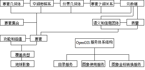
The implementation of OpenGIS requires the support of DCP(Distributed Computing Platform). Figure 17-3 describes the implementation of geographic information processing in different DCP “scenarios” following the OpenGIS specification. But the abstract specification itself is independent of DCP, and it can be implemented in any DCP. Fig. 259 Following the OpenGIS specification, geographic information processing is implemented in different distributed computing “scenarios” [OGC] # 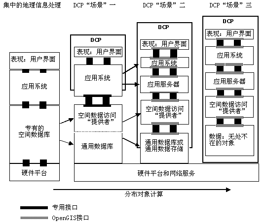
Other standards-setting organizations and standards for Geographic Information Systems
American Spatial Data Metadata Standard and Spatial Data Conversion Standard developed by the Federal Geographic Data Commission (FGDC): FGDC is a coordinating organization of U.S. government agencies. Its main purpose is to promote the common development, use, sharing and dissemination of geographic data throughout the country.
Indentification: including data names, developers, data description areas, topics, current situation, restrictions on data use, etc;
Data Quality: definition of data quality, data accuracy, integrity, consistency, raw data generated from the data and processing process;
Spatial Data Organization: the organization of spatial data in digital coding, the number of spatial entities and other attributes except spatial coordinates;
Spatial Reference: map projection, storage format (vector or grid) and horizontal and vertical earth reference system are used to transform data from one coordinate system to another;
Entity & Attribute Information: geographical information included in the data, the encoding method of information, and the description of the meaning of encoding;
Distribution: how to get data, data format, storage medium, price, etc;
Metadata Reference: when and by whom the data is completed.
The Spatial Data Transfer Standard (SDTS) is an exchange format standard currently adopted by many government departments and commercial organizations in the United States. SDTS is a hierarchical data transformation model that defines the concept, logic, and format of data transformation at three levels, while using metadata to assist in data transformation and evaluation. The conceptual layer establishes a model of geographic features and their characteristics, which can be vector data or raster data, providing definitions for standard entities and attributes of geographic features. The logical layer transforms conceptual geographic elements into logical models, records, data items, and sub items, providing the foundational content for various spatial data types and relationships. The physical format layer of SDTS defines file formats that comply with standards for converting spatial data. SDTS enables the conversion of any two types of spatial data with minimal information loss, playing a decisive role in the implementation of NSDI (National Spatial Data Infrastructure).
Mercator GIS Standard of Canada: Mercator is named after Mercator Projection. It is a national GIS data standard organized and established by the Canadian government. Its main goal is to establish the standard of spatial geographic information and the storage of spatial data and develop related software. Mercator defines a program interface called OGDI (Open Geospatial Data Store Interface), which supports access to spatial data in client/server mode.