The meaning of the data #
Data #
Data is the carrier of load information. It can be a recognisable physical symbol recorded, the specific forms of data are various, such as text, image, sound and so on, which can be classified into the category of data. Although data is the carrier of information, it is not information, only by understanding the meaning of data and explaining the data, we can get the information contained in the data. In a computerized information system, the format of data is often related to a specific computer system, which changes with the form of the physical equipment that loads it. Information systems process data (operations, sorting, coding, classification, enhancement, etc.) in order to obtain the information contained in the data.
In GIS, various thematic maps and statistical charts input by the system builder and stored by the machine are data; the code contained in the system software is binary data in the computer system; the various instructions issued by users to GIS are data, etc. Therefore, the establishment and operation of geographic information system is the process of information or data flowing in a certain way.
Data processing and interpretation are very important. The so-called data processing refers to the operation of collecting, screening, sorting, merging, transforming, retrieving, calculating, analyzing, simulating and predicting data, its purpose is to transform data into a form which is convenient for observation, analysis, transmission or further processing; to process data into data useful for correct management and decision-making; and to store data after editing for continuous use. Data processing is for interpretation, and data interpretation needs human wisdom, knowledge and experience.
Basic characteristics of geographic data (spatial data) #
Geographic data generally possesses three fundamental characteristics:
Attribute Characteristics (Non-spatial Data): Represent actual phenomena or attributes, such as variables, classifications, quantitative characteristics, names, etc.
Spatial Characteristics (Locational Data): Describe the spatial position or geographic location of phenomena. Also referred to as geometric or positional characteristics, these are generally represented by coordinate data, such as Cartesian coordinates.
Temporal Characteristics (Time Scale): Refer to changes in phenomena or objects over time, with variation cycles that can be ultra-short-term, short-term, medium-term, long-term, etc. (Figure 5-1).
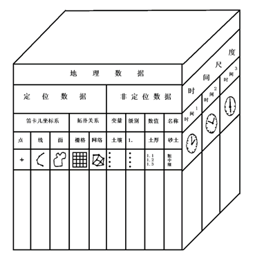
Fig. 62 Basic characteristics of spatial data [Jack Dangermond, 1984] #
Type of spatial data #
In GIS, according to its characteristics, data can be divided into three types: spatial feature data (location data), temporal attribute data (scale data) and thematic attribute data (non-location data). For most GIS applications, time and thematic attribute data are combined as attribute feature data, while spatial feature data and attribute feature data are collectively referred to as spatial data (or geographic data). Spatial feature data record the location, topological relationship and geometric characteristics of spatial entities, which is the symbol of the difference between GIS and other database management systems. Spatial features refer to geometric features such as position, shape and size of space objects, as well as the topological relationship with adjacent objects. Location and topological features are unique to geographic or spatial information systems, spatial positions can be described by different coordinate systems, such as longitude and latitude coordinates, some standard map projection coordinates or arbitrary rectangular coordinates. In general, human localization of spatial objects is not by memorizing their spatial coordinates, but by determining the spatial location relationship between a certain object and other more familiar objects, which is often also a topological relationship. Such as a school is located at which intersection or street. Thematic features refer to the various properties of geographic entities, such as the slope of the terrain, the direction of the slope, the annual rainfall of a certain place, the type of acidity of the land, the population density, traffic flow, and the degree of air pollution. Such features can be stored and processed in other types of information systems, thematic attribute features are usually represented in the form of numbers, symbols, text, and images. Time attribute refers to the time change of geographical entities or the time of data collection. Strictly speaking, spatial data is always acquired or calculated in a specific time or period. Because some spatial data change relatively slowly with time, they are sometimes ignored; sometimes, time can be regarded as a feature of a topic.Spatial feature data #
Thematic feature data #
Time feature data #
Representation of spatial data #
In general, spatial data representing geographic phenomena can be subdivided into:
Type data: For example, the distribution of archaeological sites, road lines and soil types;
Area data: For example, the center point of a random polygon, the administrative area boundary, and the administrative unit;
Network data: For example, road intersections, streets and neighborhoods;
Sample data: For example, the distribution area of weather stations, routes and field plots;
Surface data: eg elevation points, contours and equivalent areas;
Text data: such as place names, river names and area names;
Symbol data: For example, dot symbol, line symbol and polygon symbol (halo), etc. (as shown in Figure 5-2).
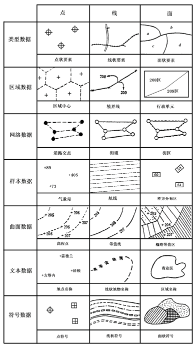
Fig. 63 Various data in GIS and their representation #