Geographic Information System #
Geographic Information system (GIS) is a kind of decision support system, which has various characteristics of information system. The main difference between GIS and other information systems is that the information stored and processed by GIS is geo-coded, and the geographical location and the attribute information related to this location has become an important part of information retrieval. In the Geographic Information system, the real world is expressed as a series of geographical elements and geographical phenomena, which are at least composed of spatial location reference information and non-location information.
The definition of geographic information system consists of two parts. On the one hand, GIS is a discipline and a new cross-discipline describing, storing, analyzing and outputting spatial information. On the other hand, geographic information system is a technical system, which is based on geospatial database and uses geographic model analysis method to provide a variety of spatial and dynamic geographic information at the right time, which serves for geographic research and geographic decision-making.
Geographic information system has three characteristics:
It has the ability of collecting, managing, analyzing and exporting many kinds of geographic information, which is spatial and dynamic;
It is supported by computer systems for spatial data management and employs computer programs to simulate conventional or specialized geographic analysis methods. These processes operate on spatial data to generate valuable information and accomplish tasks that would be challenging for humans to complete;
The support of computer systems is a crucial characteristic of Geographic Information Systems (GIS), enabling rapid, precise, and comprehensive spatial positioning and dynamic process analysis of complex geographic systems.
The external form of a Geographic Information System is manifested as computer hardware and software, while its essence constitutes a geospatial information model organized by computer programs and geographic data. When a user with relevant geoscientific knowledge operates a GIS, the data they encounter is no longer meaningless; rather, it represents abstracted and modeled spatial data of the objective world. Users can observe various aspects of this real-world model according to their application objectives, obtaining information for analyzing and predicting natural processes to support management and decision-making, this is the fundamental significance of a Geographic Information System.
A logically scaled-down, highly informatized geographic system functionally simulates the geographic system visually, metrically, and logically. The flow of information and its outcomes are entirely simulated through the execution of computer programs and the transformation of data. Supported by the GIS, geographers can extract spatial and temporal characteristics from various aspects and levels of the geographic system. They can also rapidly simulate the evolution of natural processes or the outcomes of cognitive reasoning, thereby obtaining results for geographic prediction or “experimentation,” selecting optimal solutions, and applying them to management and decision-making.
Geographic Information System and 4M
For users of geographic information such as geographers, urban planners, and resource managers, they observe and measure environmental parameters and create maps that describe the characteristics of the Earth; they monitor changes in their surroundings and model the processes and activities that impact the environment. These four activities (4M) can all be improved and enhanced through the application of GIS technology.
Types of Geographic Information Systems #
Geographic information systems can be divided into three categories according to their content:
- Thematic Geographic Information Systems (Thematic GIS)
It is a type of Geographic Information System designed with focused objectives and specialized characteristics, serving a specific purpose. Examples include Forest Dynamic Monitoring Information Systems, Water Resources Management Information Systems, Mineral Resources Information Systems, Crop Yield Estimation Information Systems, Grassland Resources Management Information Systems, and Soil Erosion Information Systems.
- Regional Geographic Information Systems (Regional GIS)
A Regional GIS primarily aims to support comprehensive regional studies and provide integrated information services. It can be established at various scales, such as national, provincial, municipal, or county levels, serving different administrative divisions. It can also be organized based on natural zones or river basins. Examples of Regional GIS include the Canadian National Geographic Information System and the Yellow River Basin Information System in China. Many practical geographic information systems are regional-thematic systems that fall between the two categories mentioned above, such as the Soil Erosion Information System of Beijing, the Land Evaluation Information System of Hainan Island, and the Winter Wheat Yield Estimation Information System of Henan Province.
- Geographic Information System Tools or GIS Shell (GIS Tools)
It refers to a suite of software packages equipped with fundamental GIS capabilities, including graphic and image digitization, storage management, query and retrieval, analytical operations, and various output methods. These packages are either specifically designed and developed or derived from practical GIS implementations by removing specific regional or thematic spatial data. They exhibit strong adaptability to computer hardware, high efficiency in data management and operation, and possess powerful, universally applicable functions as practical information systems. Additionally, they can also serve as educational software for GIS instruction.
By establishing regional or thematic geographic information systems with the support of universal GIS tools, it not only saves human, material, and financial resources for software development, shortens the system establishment cycle, and enhances the technical level of the system, but also makes GIS technology more accessible for widespread adoption. Furthermore, it enables geoscientists to devote more energy to the development of high-level application models.
Components of Geographic Information System #
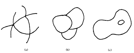
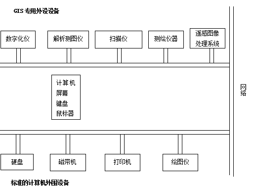
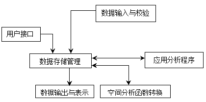
Similar to a conventional information system, a complete GIS primarily consists of four components: computer hardware systems, computer software systems, geographic data (or spatial data), and system management operators. Its core is the computer system (software and hardware), spatial data reflects the geographic content of the GIS, while managers and users determine the system’s operational methods and information representation. The system composition is illustrated in Figure 1-4. Fig. 4 Components of Geographic Information System # A computer hardware system is a general term for actual physical devices in a computer system, which can be an electronic, electrical, magnetic, mechanical, optical component or device, and is a physical enclosure of a GIS.The scale, accuracy, speed, function, form, usage and even software of the system have a great relationship with the hardware and are supported or restricted by hardware indicators. Due to the complexity and particularity of its tasks, GIS must be supported by computer equipment. The basic components that make up a computer hardware system include input/output devices, central processing units, memory (including main memory, auxiliary memory hardware [ 3 ] ), etc., which work together to provide the necessary information to the computer system to complete task; Save the data for current or future use; provide the results or information processed to the user. Figure 1-5 shows a common computer peripheral that implements the input and output functions. Fig. 5 Standard Computer Peripherals and GIS-Specific Peripherals # Computer Software System refers to all kinds of necessary programs. For GIS applications, which usually includes: 1) Computer System Software Program systems provided by computer manufacturers to facilitate users’ computer operations. These typically include operating systems, assemblers, compilers, diagnostic programs, library programs, along with various maintenance manuals and program documentation. They are essential for the daily operation of GIS. 2) GIS Software and Other Supporting Software This includes general-purpose GIS software packages, and may also encompass database management systems, computer graphics software packages, computer image processing systems, CAD, etc., used to support the input, storage, conversion, output of spatial data, and user interfaces. The functional structure of a GIS software package is illustrated in Figure 1-6. 3) Application Analysis Program It is a program compiled by system developers or users for a specific application task according to the geographic thematic or regional analysis model, and it is the expansion and extension of the system function. With the support of GIS tools, the development of applications should be transparent and dynamic, independent of the physical storage structure of the system, and constantly optimized and expanded with the improvement of the application level of the system. Applications act on geographic thematic or regional data to form the specific content of GIS, which is not only the part that users are most concerned about for geographic analysis, but also the key to extract geographic information from spatial data. Most of system development work undertaken by users involves creating application programs, and the quality of these applications largely determines the system’s applicability, effectiveness, and ultimate success. Fig. 6 Functional framework of GIS software # Human is an important component of GIS. GIS is different from a map, but a dynamic geographical model. Only the system software and hardware and data can not constitute a complete geographic information system, which requires people to organize, manage, maintain and update the data, expand and improve the system, develop application programs, and flexibly use geographic analysis models to extract a variety of information to serve research and decision-making. For qualified system design, operation and use, GIS professionals are the key to the application of GIS, and a strong organization is the guarantee of system operation. A well-planned Geographic Information System project should include a project manager responsible for system design and implementation, technical personnel for information management, application engineers for system customization, and end-users who will ultimately operate the system. It refers to natural, social, and human-economic landscape data referenced by spatial locations on the Earth’s surface, which can be in the form of graphics, images, text, tables, and numbers. It is input into the GIS by the system creators via digitizers, scanners, keyboards, tape drives, or other communication systems, serving as the object processed by system programs and representing the abstracted substantive content of the real world modeled by the GIS. Within a GIS, spatial data primarily includes: 1) Position in a known coordinate system That is, geometric coordinates that identify the spatial position of geographic features in the natural world or within a map containing a specific area, such as latitude and longitude, plane rectangular coordinates, polar coordinates, etc. When input using a digitizer, digitizer rectangular coordinates or screen rectangular coordinates are typically used. 2) Spatial relationship between entities Spatial relationships between entities typically include: metric relationships, such as the distance between two features; directional relationships (or orientation relationships), which define the orientation between two features; and topological relationships, which define connections and adjacencies between features and are the most fundamental relationships in GIS analysis. These include the hub relationship between network nodes and network lines (Figure 1-7-a), the compositional relationship between boundary lines and area entities (Figure 1-7-b), and the containment relationship between area entities and islands or internal points (Figure 1-7-c), among others. Fig. 7 Several typical topological relationships # 3) Properties independent of geometric position This refers to what is commonly known as non-geometric attributes or simply attributes, which are geographic variables or meanings associated with geographic entities. Attributes are divided into qualitative and quantitative types: the former includes names, types, and characteristics, while the latter includes quantities and ranks. Qualitatively described attributes include soil types and administrative divisions, while quantitative attributes include area, length, land grades, and population numbers. Non-geometric attributes are generally abstract concepts obtained through classification, naming, measurement, and statistics. Any geographic entity has at least one attribute, and the analysis, retrieval, and representation in a Geographic Information System are primarily achieved through the manipulation and computation of attributes. Therefore, the classification system of attributes and measurement indicators significantly influence the system’s functionality. Three views on GIS [Maguire, 1991] Regarding the definition of GIS, there are three perspectives: the map view, the database view, and the spatial analysis view. The map-based definition emphasizes cartography-related content, thus considering GIS as a map analysis and processing system. The database-oriented definition of GIS focuses on the perfection of database design and implementation, where a complex database management system is regarded as an integral part of GIS. The spatial analysis perspective emphasizes analysis and modeling, viewing GIS as a science of spatial information rather than merely a technology.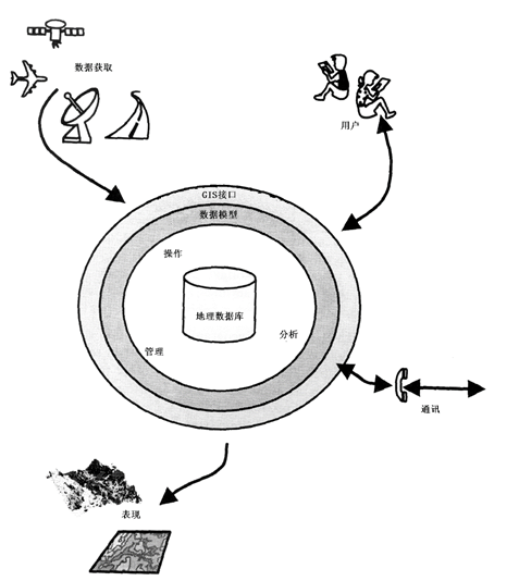
Computer Hardware System #
Computer Software System #
System development, management and use of personnel #
Spatial data [ 4 ] #