Toggle navigation
GISLite
Document
Info
Tutorial
App
Map
User
Recent use
Most use
My collection
Personal Data
Login
Register
Current location:
Home
Map
China Nature Disaster
Text
×
Based on WebGIS technology, the map can be online browsing, zoom, and can also be used for different map overlay operation.
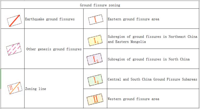
Online Distribution Map of Ground Fissures in China
Date:
2023-08-23
Editor:
admin
View counts:
299
Full screen
Help edit
Category:
China Nature Disaster
Save view
https://www.gislite.com/map/ma9f2
Central point longitude
105.0
Central point latitude
40.0
Max zoom level
7
Min zoom level
4
Current zoom level
4
Map description
Online Distribution of Ground Fissures in China
Sign in
for comments!
Submit
Comment list (
0
)
Map evaluation
Map reference
Map overlay
Login
for more operation .
Correlation maps
Online map of meteorological condition of the forest fire in Greater Higgnan Mountains in June 29th, 2010
Online map of accumulated precipitation of flood disaster in southern China from July 11 to 17, 2014
Online map of earthquake epicenter and disaster distribution in China in 2014
Online map of remote sensing monitoring in the key sea ice disaster area in the north of the Bohai Sea and the Huanghai Sea in January 13th, 2010
Online Map of Southwest Drought Hydrological and Meteorological Drought Process in May 2010
Epicentral online distribution map of the Chinese earthquake (2300 BC - 2000, December, magnitude 4 or above)
Online map of meteorological condition of the forest fire in Greater Higgnan Mountains in June 26th, 2010
Online map of drought and precipitation analysis in Southwest China from March 22 to May 6, 2010
Recent maps
1981-2010 Africa Suitability Index Distribution Map
2011 Population Count Distribution Map of India
2100 Global Urban Population Forecast Distribution Map
2090 Global Urban Population Forecast Distribution Map
2080 Global Urban Population Forecast Distribution Map
Mostly reviewed maps
Historical map of the Southern Song Dynasty and the Jin Dynasty in 1208 AD
Historical Maps of Chu State, Wu State and Yue State in Spring and Autumn Period of China
The Historical Maps of Qi State, Lu State and Song State During the Warring States Period in China
A Historical Map of the Early Site of Chinese Primitive Society (Paleolithic Age)
Online map of the maximum daily rainfall in July 16th,2010 during the mid and late July's flood disaster period in South China
Powered by TorCMS (
https://github.com/bukun/TorCMS
).