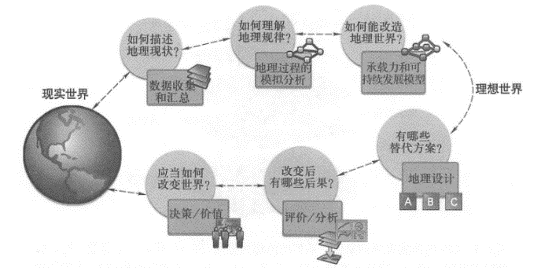
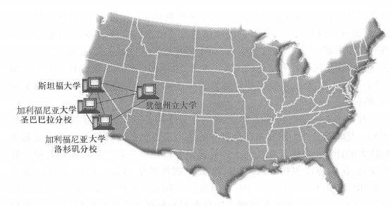
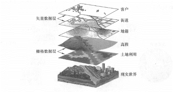
互联网和万维网的发明是人类文明发展史上的重要里程碑。 它们铺设了一条信息高速公路,改变了我们的生活和工作方式,让人类社会步人了一个前所未有的信息化时代。 在介绍万维网地理信息系统之前,让我们首先了解互联网、万维网、移动网和地理信息系统的出现和演变。 在20世纪60年代“冷战”期间,美国国防部的高级研究计划署(ARPA)启动了一个网络研究项目, 其目的是建立一个分布式的计算机网络,即使其中的一些节点不能工作或被核武器摧毁时,依然能够进行信息交换。 1969年,该项目组成功地连接了美国西部四所大学 (斯坦福大学、加利福尼亚大学圣巴巴拉分校、加利福尼亚大学洛杉矶分校和犹他州立大学)的计算机(图1. 1 ), 这标志着互联网的产生。 Fig. 1 The Advanced Research Projects Agency network successfully connected computers at four universities in the western United States in 1969. It is the predecessor of today’s Internet and marks the birth of the Internet. # 高级研究计划署网络(ARPANet)就是今天互联网的前身。 随后,这个网络由军用转为民用,一些政府部门、大学和研究机构的计算机逐步加入到该网络中。 到1975年底,该网络的计算机数量达到57台; 到1989年底,达到100 000台。 20世纪90年代以前,互联网并不像今天这样流行, 因为当时互联网上的内容和所能提供的服务有限, 主要有电子邮件、新闻讨论组(不同于今天基于万维网的讨论组)、文件传输和远程登录。 使用复杂,内容也不像现在这样丰富多彩,所以其用户基本上都是研究机构和政府部门的专业人员。 1989年,欧洲粒子物理研究所(CERN)的一位科学家(Tim Bemers-Lee),极大地改变了互联网的使用方式。 当时他在寻求一种简单的方法来与同事分享和交换文件。 1989年,他在一个项目建议书中描述了万维网的设想。 1990年,他编写了第一个网页以实现他的设想。 在这个研究中, 他发明了 HTTP (Hypertext Transfer Protocol;超文本传输协议)、 HTML ( Hypertext MarkupLanguage;超文本标记语言)和URL (Uniform ResourceLocator;统一资源定位符)。 他把自己的发明命名为万维网(World WideWeb),开发了世界上第一个Web服务器和Web浏览器, 因而他被称为“万维网之父”(图1.2)。 Fig. 2 Tim Berners-Lee -“Father of the World Wide Web” # The World Wide Web has made the Internet fun and easy to use. It has completely changed the way we work and live, expanding the main role of computers from computing to daily communication and entertainment. Since then, the World Wide Web has expanded rapidly, and the number of computers, websites, resource types and users on the Internet has increased exponentially (International Telecommunication Union,2011). People are becoming more and more accustomed to surfing the Internet instead of having to pay for subscriptions to newspapers; e-mail has the speed of light and reaches the ends of the earth in an instant, which cannot be compared with express delivery; we send dozens of domestic and international e-mails every day without having to rush to the post office; and using online shopping and auction sites such as eBay and Amazon, you can shop around and find the best deals without leaving home. Using social networking sites such as Facebook and Renren, you can easily find old friends and make new ones. By using Twitter and Weibo, you can always keep track of the big and small situations in the world or what your friends are thinking. For many people, video websites have rich content and personalized channels, making them more attractive than TV. Instant Messenger brings you closer to your family far away, listen to their voices, see their people, and chat at any time without worrying about phone bills; using free online photo albums, you can share thousands of photos with friends around the world without having to develop and mail them; people no longer have to open the thick phone book. They can find the business information they need online with a click of the mouse. Through video conferencing, people can meet customers and discuss business while sitting comfortably in the office, instead of having to wake up early and late to catch planes and trains, saving a lot of travel expenses and hard work. Today, the World Wide Web has become an indispensable part of modern society, and many people, especially those who grew up with the Web, cannot even imagine what life would be like without the Web. 在很多人的脑海和谈话中,互联网和万维网是同义词,但实际上它们有所不同。 是一个把分布在全世界的数以百万计的计算机等设备连接起来的巨大的计算机网络。 互联网上的计算机可以通过一系列的协议与其他计算机交流, 这些协议包括 HTTP 、SMTP(简单邮件传输协议)、FTP(文件传输协议)、IRC(互联网中继聊天)、IM(即时通信)、Telnet(远程登录)、P2P(点对点或对等网络)等。 是互联网上的众多网站和超文本文件的集合,它主要通过超文本传输协议把各种超文本文件连接起来。 超文本传输协议虽然只是互联网协议中的一个,但它所聚集起来的丰富内容和所能支持的用户交互活动, 是互联网最主要的吸引力,因此,万维网被称为是互联网的“门面”(Douglas,2008)。 In recent years,iPhone and iPad have become popular around the world with their fascinating user experience, leading the development trend of smartphones and tablets. Smartphones and tablets have sprung up everywhere and are rapidly spreading, and the number of mobile users continues to grow. The International Telecommunication Union estimates that the number of subscribers to global mobile wireless networks reached 6 billion at the end of 2011 (note: uneven distribution, with some people having multiple mobile phones and tablets)(International Telecommunication Union,2011). Wireless fidelity (Wi-Fi) technology, 3G and 4G cellular mobile communication technologies are also developing rapidly. More and more users are subscribing to mobile broadband networks, driving further explosive growth of the Internet and the World Wide Web. Looking to the future, wireless networks will be many times larger than wired networks, allowing people to enjoy the freedom and fun of surfing the Internet anytime and anywhere. 世界上发生的每件事情都与一个地方相关联。 知道某事某物在哪里和它们为什么在那里,这些对于人们做出正确的决定都是至关重要的。 GIS (地理信息系统,geographic information system; 或地理信息科学,geographicinformationscience),是一门处理与地理位置有关的问题的,能够对地理数据进行采集、储存、管理、分析、表达和共享,帮助人们做出正确决策的技术和科学。 地理信息系统的出现比互联网更早一些。 1962年, Roger Tomlinson(图1.3)为加拿大联邦政府林业和农业发展部开发了世界上第一个可操作的地理信息系统, 称为“加拿大地理信息系统”,用于加拿大土地利用的详查、统计和规划。 Roger Tomlinson开创了 GIS,并致力于推动GIS方法论的发展(Tomlinson, 2011), 因而被称为“地理信息系统之父”。 尽管GIS通常用于编制地图,但是它的功能远不限于此,它具有强大的分析功能, 能将很多看似无关的数据以它们共同的地理位置为基础关联起来,并能进行综合分析, 将那些在电子表格或统计软件包中隐藏的或不容易显示的关系、规律和趋势挖掘出来,以支持人们做出科学决策。 GIS可以把现实世界抽象成一系列的空间数据层,如土地利用、高程、图像、街区、道路和商业客户等(图1.4)。 Fig. 3 GIS abstracts the real world into a series of geographical data layers, each layer representing a topic. These data layers can be displayed in two-dimensional or three-dimensional maps, and can also be used for geographical analysis and simulation to solve practical problems in the real world # GIS可以把这些图层以多种方法组合起来,绘制成多种专题地图 , 而且,GIS还可以对这些图层进行更进一步的分析,从中提取出大量有用的信息,解决诸如下面的问题: Analysis method: Buffer zone analysis can be used to make a rough estimate (such as 50 meters away from the river), or three-dimensional surface models can be used for relatively more accurate analysis. Information on precipitation and flood processes can also be combined to establish a more accurate flood inundation model. Consider natural precipitation and flood peak processes, and dynamically simulate the inundation scope and inundation process. Application: Government departments can use this result to formulate relevant policies, conduct regional planning and emergency management. For example, which areas have high flood risk factors and are not suitable for development into residential areas? If a flood is about to break out, which places should residents be evacuated first and where should they be evacuated? Analysis method: Using geographical information system overlay analysis, insurance companies can overlay the above-mentioned flooded areas with their customer distribution layers to determine which customers ‘houses are more likely to suffer from floods. Application: Insurance companies can set different charging standards for users in different regions, and can also calculate in advance the total amount of claims that may be needed if a flood breaks out to calculate investment risks. Analysis method:GIS technology can find low-lying and sparsely populated places on both sides of the strait as flood discharge areas and select the best breakwater site. Application: Governments can make plans and emergency rescue personnel can make preparations in advance to reduce losses and save lives. The above is just a simple example of a GIS application. Since the emergence of GIS, the GIS industry has established a theoretical foundation for data management, visualization and spatial analysis and developed a variety of products, enabling GIS to be used in urban planning, land management, environmental protection, market analysis, public safety and ecosystem simulation. It plays an important role in many fields. In these applications, the role of GIS goes far beyond the scope of cartography. Its rich analytical functions help people use spatial thinking models to discover hidden relationships, spatial distribution laws and evolution trends of things, and make intelligent decisions. Geographical information systems are the supporting science and technology of GeoDesign (Figure 1.5). They can introduce geographical analysis into all design processes related to geospatial factors, create a systematic methodology and toolset for geographical planning and decision-making, and help people understand, analyze and solve many of the world’s current problems (Steinitz,1990; Dangermond, 2009a). In the past few decades, the development and application of GIS have benefited many fields. The emergence of the World Wide Web has provided GIS with a broader stage, allowing GIS to move into more industries and reach thousands of households. Fig. 4 Geographic information systems are an important support for geospatial design. They can introduce geographical analysis into all design processes related to geospatial factors # Internet, World Wide Web and Mobile Web #

Geographic Information System #
GIS应用场景 #
If there is a flood, which areas are more dangerous? #
Which customers may be affected? #
If floods occur, how to deal with them? #
未来应用 #