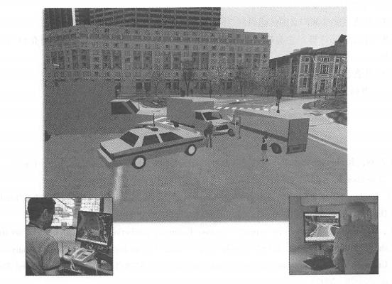
Looking to the future, the next generation Internet will be faster and more mobile. The future World Wide Web will be richer, more friendly, more social and intelligent, and WebGIS will continue to develop vigorously. The Internet, which emerged as a method of communication between computers in the late 1960s, has developed into an important part of modern society and people’s daily lives, and has become an important national and global infrastructure. It connects billions of people around the world through mobile devices such as desktop computers and mobile phones, and provides numerous applications. These applications benefit from the Internet and also place new demands on the Internet. Online photo albums, Internet telephony, video sharing websites, video conferencing and online games have generated huge traffic and put forward exponential growth requirements for bandwidth. In addition, applications and personal communications such as e-government, e-commerce, scientific research informatization and health informatization also put forward higher security requirements for the Internet. Faced with these needs, many countries are actively studying how to improve the Internet, such as the Next Generation Internet (NGI ) in the United States, the Global Environ ® for Network Innovations (GENI), and future Internet design (Future Internet Design (FIND); Japan’s Next Generation Network (NXGN) and New Generation Network (NWGN); Europe’s Future Internet Re © search and Experiment (FIRE) ; China’s Next Generation Internet 7K Model Project and other research projects. Many countries participate in the Global Terabyte Research Network (GTRN) to research and develop the next generation Internet (ITU, 2009;EberSpacher and Tmn-Gia, 2008). The future Internet will have the following characteristics. Faster: For example, Internet 2 provides backbone networks at speeds of 100Gbit/s to more than 300 educational institutions, companies, non-profit organizations, and government agencies in the United States. Researchers at Bell Labs in the United States successfully used 2. Transfer data at a speed of 05 Tbit/s (Gardner,2008). The popularity of these studies will help most Internet users enjoy higher transmission speeds. More IP addresses: Current Internet IP addresses are running out. The current IPv4(In-ternet Protocol version 4) standard on the Internet uses 32-bit addresses, which supports 2 to the 32nd power, or approximately 4 billion IP addresses. IPv6( Internet Protocol version 6) may replace IPv4, which will support 2 to the 128th power IP addresses. In theory, based on the current world population,IPv6 will allow every person in the world to have 16 million IP addresses. The implementation of IPv6 will help the realization of the Internet of Things, smart cities and smart earth. The significance involved in this is huge-all mobile devices and sensors, such as mobile phones, cars, refrigerators and sensor networks, can each have a unique device. One IP address, which facilitates their access to the Internet and facilitates people’s remote control of them. Better mobility:3G and Pre 4G networks are already in use in more and more countries. The speed of a real 4G network will reach 100 Mbit/s. The data transmission speeds provided by LTE-Advanced and WiMAX will soon reach 1 Gbit/s, which will likely become the basic technology of wireless communications in the future. In terms of spatial coverage, the coverage area of wireless networks will also be further expanded. Moreover, the charges for satellite communications will gradually be reduced to a range acceptable to the public. Even people in remote mountainous areas and vast seas can obtain stability and fast Internet connection. More secure: Relevant research and architecture design of the next generation Internet have fully considered security issues from the beginning, and the controllability and manageability of network security will be greatly enhanced. More popular: The Internet, broadband networks, and high-speed mobile networks will continue to become popular, connecting more people, whether they are at home, in the office or on the road, whether they are in a prosperous city or a tranquil countryside. In 2005 and subsequent years,”Web 2. The word 0 “was very popular for a while.“ Web 2. 0 “is often considered a” hot word “or hype, and Bemers-Lee, the father of the World Wide Web, once criticized” Web 2. 0 “is a meaningless dream talk (Laningham, 2006). Although it adds a version number to the World Wide Web, it does not involve any upgrades to the World Wide Web technology and specifications. While criticizing the term “Web 2.0”, Berners-Lee believes that the future Web will implement the Semantic Web (Berners-Lee, Hendler, and Lassila, 2001), which others call “Web 3.” 0”(Strickland, 2008)。 The characteristics that the World Wide Web has demonstrated in recent years and the possible development direction in the future are as follows. Readable: Users can no longer simply accept information from websites, but can also express their own voices. Users can post blogs, Weibo, comments, map annotations, etc. Some websites use “crowdsourcing” methods to encourage user participation and accumulate data resources to attract more users. More social: such as? 3001) 001 {, 1Jie Edition 1’Shan1111 « 01111, Weibo and Renren.com connect family, classmates, colleagues, friends and business partners, forming a social interpersonal network. People use this to connect with each other and disseminate information to a wider audience faster than traditional media. Multimedia: Multimedia is more intuitive and easier for people to accept and understand. The popularity of photos, video websites and Pod-casts reveals people’s love for multimedia. Voice-based Internet access: The finger is arguably the most portable and convenient mouse, so currently touch-screen mobile phones and tablets are deeply loved and popular by people. Similarly, speech can be said to be the most natural, convenient and humane way for humans to issue orders. Voice-based human-computer interaction will be a hot spot. The speech recognition and interaction functions of Apple’s iPhone 4S have certain intelligence, which is one of the reasons why it is popular. In the near future, people will be able to use their voice to surf the Internet and interact with online applications. Smarter: Currently, content on the Web is mainly for people to read rather than for computers to directly understand, and human language is vague, multi-meaning and ambiguous. Applications on the World Wide Web do not fully understand the human language on the World Wide Web. For example, search engines complete searches through spelling matches of words rather than the meaning of words, which leads to problems such as information omission, that is, missing pages that users actually need, and information overload, that is, search results contain a lot of irrelevant and unimportant information. The purpose of the Semantic Web is to solve these problems. In the Semantic Web, the meaning (semantics) of words are pre-identified and can therefore be understood and processed by machines. One way to do this is to tag terms on a web page with semantic tags, each tag having a unique URI, and each URI corresponds to a term in a Web ontology language (OWL)(see Section 6.3). The Semantic Web is a grand project. Building a comprehensive ontology system and marking semantics on every Web page requires a lot of effort from Web standard setters and Web page developers. Although there are a large number of such projects, they are all small-scale experimental studies, and it will take time to realize a true Semantic Web. After the implementation of the Semantic Web, software can accurately understand the meaning of every term in the World Wide Web and process it automatically and intelligently. For example,Berners-Lee gave an example of meeting notices: “A meeting notification website often contains a meeting schedule and a lot of related information. When users click on the meeting schedule link, they can immediately add the meeting time and date to their electronic calendar; at the same time, the location information of the meeting (such as address, latitude and longitude, or even altitude) can also be sent to his GPS device; and the names and resumes of other attendees can also be sent to his IM list. Q In other words, once developers agree on a set of commonly defined semantics, their program can understand each tagged word without ambiguity and add a series of intelligent, automated functions to that word.”(Shannon,2006) It is very difficult to accurately predict how and to what extent WebGIS will develop. However, based on the experience, lessons and the general trend of information technology development since its inception, WebGIS will develop in the following direction in terms of technology, architecture and application. Open geospatial Web services will continue to be the core of WebGIS Web services are the basic module of geospatial information aggregation and cloud GIS, and are NSDI 2. A solid foundation for 0. It develops GIS data and functions to other programs on the Internet, providing a flexible channel for sharing geospatial data and functions. This cross-department collaboration will create a geospatial Web services ecosystem that will spawn more newer applications and maximize the output and return of human society’s investment in geographical information. Currently, map services are the most common type of service. In the future, people will create more and more other types of services such as geoprocessing to achieve richer functions. REST-style Web services are simple and easy to use, which helps improve the overall performance and extensibility of the WebGIS system, and will further achieve SOAP-type Web services. Most of the currently widely used browser-side APIs (such as APIs for JavaScript, Flex, Silveriight) and APIs for mobile platforms such as iOS and Android are based on the REST service type Q, which creates services on the server and integrates services on the client. The application construction method will become more popular. Mobile platform will become the main client of WebGIS Modern society is entering the post-PC era (Jobs, 2011). Smartphones, tablets and various portable digital devices are becoming increasingly popular and popular, and the market share of PCs is relatively shrinking. In the next few years, the number of smart mobile will surely surpass desktop and notebook computers and become the main client platform of WebGIS. The application of mobile GIS in various professional fields will also become increasingly popular, and location-based services will continue to develop rapidly and be integrated into people’s daily shopping, travel, dating and entertainment lives. Among them, augmented reality will be a research hotspot in mobile GIS. It can combine the user’s location and direction, obtain more information through the Internet to make up for the limitations of people’s vision and other senses, so that everyone can become a “golden eye”, and can see what a building looks like in history and an area is in the future. Design, even through Face Recognition technology and geographical location, you can understand who the girl you fell in love with at first sight on the street is, or whether a stranger has a criminal history. Mobile GIS can quickly record, report and analyze changes somewhere, helping to improve the real-time nature of the GIS system and expanding GIS from three-dimensional (z, r, z) to four-dimensional U, F, Z* 70. Spontaneous geographical information holds great value Spontaneous geographical information (see section 10. 1. Section 1) will become more and more abundant, and this information can be integrated with other information to support many applications, such as national science, community feedback, crowdsourcing, early warning, emergency monitoring and process analysis, and NSDI construction. VGI is also the main form of new geography and public participation in GIS, and is a unique way for citizens to use GIS to express their voices and opinions. The types of spontaneous geographical information are also expanding. Many mobile applications use and record the mobile phone user’s location with the user’s consent, so that people’s range of activities, consumption habits, political inclinations, health status and social relationships can all be obtained from the location recorded on the mobile phone. This kind of VGI will be massive and has great value in its analysis and utilization. Cloud GIS is the general trend In recent years, the concepts of cloud computing and cloud GIS have become popular, and related technologies have gradually become practical. Compared with local complex massive data processing and frequent software and hardware updates, cloud GIS appears more “light”. With cloud computing as the core and providing data and functional support for applications such as desktop and mobile, this architectural model is being accepted by people. The functions of cloud GIS are also developing from cloud storage and cloud hosting to application development platforms. Cloud GIS’s rent-payment model and a large number of free services will not only provide convenience for traditional GIS users, but will also enable GIS to penetrate into institutions and departments that have never used GIS or have been unable to afford the relevant costs before. Governments of various countries have increased their investment and use of cloud computing. For example, the U.S. government has established a cloud-first strategy and formulated 25 plans such as integrating federal data centers to promote a new wave of reforms and drive the modernization of the entire United States. upgrade. Although cloud GIS will not completely replace desktop and local GIS, and although the construction of cloud GIS will not be achieved overnight, the development and application of cloud GIS has become the general trend. WebGIS will become smarter The Semantic Web envisioned by Bemers-Lee will help eliminate or reduce limitations caused by the ambiguity, uncertainty, and inconsistency of natural language. The implementation of the Semantic Web will bring a major breakthrough in semantic interoperability to the discovery, acquisition, mining and synthesis of geospatial information. Future WebGIS will be more intelligent when analyzing data resources on the Web, extrapolating new results, and meeting various application requirements. GIS develops towards real-time or near-real-time Many components in WebGIS have real-time and near-real-time characteristics, such as monitoring data obtained from sensor networks, emergencies reported by field workers and the public using mobile devices, and locations collected by GPS receivers on helicopters, fire trucks, police cars, transport vehicles and mobile phones. They allow GIS data to be acquired, processed, analyzed, displayed and utilized in real time, a feature that is important in solving many of the challenges facing the world today. Voice interaction will flourish Simple and efficient human-computer interaction through natural language is one of the important development directions of future technology. Current technology already allows people to use voice for simple geographical interactions. For example, smartphones such as the iPhone can already answer questions such as “Will it rain here tomorrow?” “Display a map of San Diego”,”Calculate the route to Los Angeles”,”Remind me to buy Christmas gifts on the way when I leave the office”,”Remind me to call Amy when I get home to thank her for her hospitality” and other questions. Speech recognition and speech control face challenges in terms of speech ambiguity, differences in different dialects and accents, background noise and changes in user pronunciation. The interaction between people and maps is particularly complex, but it has broad development prospects and is of great practical value to users, especially when they have visual and physical injuries, defects, or are in a busy state (such as driving). Internet of Things and smart cities from fantasy to reality At present, the Internet of Things industry has become a key direction for the development of the science and technology industry in many countries. The Internet of Things is a huge social information system composed of a perception layer, a network layer and an application layer. It is an all-encompassing huge industrial chain involving all walks of life in the national economy, and all fields of society and life. This seemingly distant concept has gradually begun to be realized in our lives. For example, functions such as the Internet in cars that have emerged in recent years have initially demonstrated the potential of the Internet of Things in aspects such as entertainment, navigation, interaction, communication, remote control and road information fusion. GIS and WebGIS have important value in the planning, tracking, searching, control, display and management of the Internet of Things, and will help realize an intelligent Internet of Things smart city. Integration of virtual earth and virtual world Online virtual worlds are a hot topic, with thousands of players living in avatars (see Section 10.1.6). However, most of these virtual worlds are built on an illusory environment. In order to obtain better practical application value, these worlds can be built on the virtual earth, which is a virtual version of the real world, so that users can do real work in a virtual environment (Driver and Jackson, 2008). Today’s online virtual earth has detailed ground imagery and street basemaps, to which users can add three-dimensional buildings and other features. If you can add user avatars and add behavioral rules between avatars, and if the avatars can have in-depth integration, convenient and interesting interactions with the virtual earth, then the virtual earth will have unlimited opportunities. Imagine that using virtual earth, emergency personnel can conduct disaster response exercises in virtual traffic accidents and large-scale explosions that are very similar to real urban scenarios. Sitting in the office, they can simulate driving a helicopter to participate in rescue operations, and truly experience the situation at the scene of the accident and collaborate with other colleagues (Figure 10.10); Imagine sitting at home, you can wander the world, shuttle through virtual and real cities, enter virtual shopping squares after virtual, browse and buy goods, knock on friends ‘doors, and meet them face to face. Talk to them, shake hands and hug them through reactive gloves… This is full of potential in many GIS application areas. Fig. 124 Building the virtual world on the virtual earth has wide application potential, such as people sitting in the office can participate in realistic emergency drills. (Thanks:Pictometry Company) # WebGIS began in the early 1990s. Looking back at the time, it is impossible or difficult for people to imagine that those crude prototypes could have such great practical application value and achieve such great success. Similarly, looking to the future, it is difficult for us today to accurately predict how far WebGIS will develop in the future, but what is certain is that WebGIS will be further widely used, through wired and wireless networks, through cloud computing and ubiquitous computing, through our computers, mobile phones and other devices that will appear in the future, we will be closely associated with us, connecting you, me, and him, humans with the sensor network and the Internet of Things, and seamlessly integrating geospatial information into the government. In the operation and decision-making of business and all other organizations, integrate people’s lives and work, allowing anyone, at any time, and anywhere to use GIS to solve geospatial problems, and achieve a truly social GIS.A faster and more mobile Internet #
A more social and smarter World Wide Web #
Towards Social GIS #