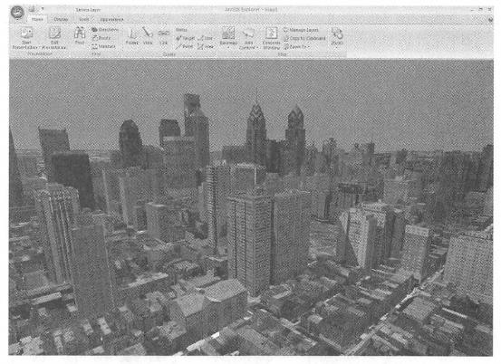
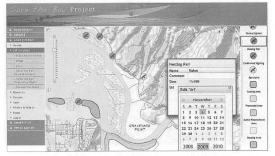
Geographical Web services can be divided into map services, data services, analysis services, and metadata services according to their functions. This section describes the functions of these service types. Map services are the most common form of geographical Web services. It allows clients to request maps within a certain geographical range, and it returns the map to the client in an image format such as JPEG, PNG, or GIF. The maps of the map service can be dynamically created or pre-made tiles. Tile map services can greatly improve the operating efficiency of WebGIS applications and shorten response time. They are mainly used for basic basemaps or maps with relatively static content or low update frequency. After receiving a request from the client, the dynamic map service reads data from the database in real time to make maps, so it is especially suitable for maps with high data update frequency. Map services can be two-dimensional or three-dimensional. A three-dimensional map service, also known as a Globe service, can use the ground elevation as the third dimension to show natural terrain; it can also use the height of a building as the third dimension, plus a texture model of the building surface to show the outline of a city or realistic street view (Figure 3.4); You can also use the value of a certain attribute field as the third dimension to highlight the theme (Figure 3. 5)。3D map services need to be displayed in a 3D client, and users can perform operations such as zooming and rotating. In addition to cartography, map services can often support functions such as attribute queries, spatial queries, and dynamic projection transformations. Feature services allow Web clients to read and write vector geographical data in the server-side geographical database, and can add, edit, and delete geographical features and their coordinates in the database. For example, ArcGIS Server’s feature services enable its clients to modify geographical data. Users can also edit the attribute data of geographical features and upload attachments such as PDFs, photos, and videos (Figure 3.6). Element services allow designers to quickly outline design sketches on digital maps and share their plans at the same time, allowing other colleagues to modify them, effectively supporting collaborative geographical design. Element services also make it easier for the public to mark on Web maps, share what they see and hear, Fig. 25 Three-dimensional map services can show terrain and urban architectural landscapes. The figure shows browsing a 3D map service from Philadelphia, USA published by ArcGIS Server in ArcGISExplorer. (Acknowledgement:PiCtometry International and U.S. Geological Survey) # Fig. 26 3D map services can also use the value of an attribute as the third dimension to highlight the theme expressed by the attribute. The three-dimensional map service shown in the figure uses the number of rental population in each county in the United States as an elevation to reflect the distribution of the rental population. (Acknowledgement: U.S. Geological Survey and U.S. Census Bureau) # Fig. 27 Element services can support Web-based online editing. As shown in the picture, citizens can mark on the map website when and where they have found endangered birds and provide relevant information. This information is stored in the server-side geographical database to facilitate government departments to delineate ecological protection. (Scratch: U.S. Geological Survey) # Promote public participation in the development of geographical information systems (PPGIS) and spontaneous geographical information (VGI; see Section 10.1). Search services can index the content of GIS resources (for example, a data layer or an entire enterprise geodatabase) and allow Web users to query and search the GIS resources they need through keywords and other methods. The search service is different from the metadata catalog service that will be introduced later in this section. Although both can support the search and discovery of GIS resources, the former indexes geographical data itself, especially the attribute table, while the metadata catalog service relies on the metadata of geographical data. Image services mainly provide raster data (such as remote sensing images and digital elevations) through Web services. It supports raster data extraction, download and map making. For example, the ArcGIS for ServerImage Extension allows remote sensing departments and others to publish a large number of acquired images into image services without pre-processing, and can perform rapid real-time processing, including splicing, enhancing, and deriving a variety of image products for Web clients. Browse and download. Geocoding services: Geocoding is the process of converting street addresses into geographical coordinates. Correspondingly, reverse geocoding is a process of converting geographical coordinates into corresponding addresses. Geocoding services publish geocoding or reverse geocoding functions in the form of the Web. Currently, there are many free geocoding services on the Internet, such as services provided by ArcGIS Online, Google, Microsoft, etc. In some cases, such as when address data in free systems such as Google is outdated or you want to match by address aliases known to locals, you can use products such as ArcGIS Sever to create your own geocoding service. Network analysis services: Geographical network here refers to the transportation network composed of streets and highways, the pipeline network organized by underground pipelines, pipeline joints, valve switches, etc. Network analysis services can provide the following functions: Calculate the best path: Given a starting point and an ending point, calculate the shortest or fastest path from the starting point to the ending point, or given multiple stations, calculate the shortest or fastest path that can be traversed. Routing services should consider speed limits and turning rules, and can also consider traffic jams, traffic signal waiting times and roads (due to Construction or accidents) shutdown and other factors. Calculate service area: Calculate the blocks that can be reached from one or more points within a certain driving time. Service area analysis can help users assess the coverage or accessibility of a location, for example, it can help city planners choose the best fire station address so that it can cover a designated area in minutes, or help retailers choose the best store address so that it can serve better services. Many potential customers (Figure 4.9C). Find the nearest facility: Find the facility that is closest to a point or has the least driving time. This is common in location-based services (LBS), such as finding the restaurant or post office closest to a mobile phone user. Geometry services: It can perform geometric transformation, buffer calculation, cartographic generalization (feature simplification), merge, cut, calculate area and length, coordinate projection conversion, etc. Geoprocessing services: Geoprocessing services can publish multiple functions and analytical models created by users into Web services. Geoprocessing services have a wide range of functions, from simple buffer analysis and area overlay analysis to complex regression analysis and image classification, from local community planning to global climate change analysis, from simulating the past to predicting the future. Examples of geographical analysis in this book include light potential calculation (Figure 2.11 ), diffusion analysis of chemical drug leaks (Figure 1.8 and Figure 5.14), and visualization area calculation (Figure 4. 9A) and terrain profile calculation (Figure 4.9D), etc. Metadata is data about data that can describe GIS data and services. Metadata catalog services can be used to publish and search metadata and can facilitate the sharing of geographical information and services. For example, a provider can publish metadata about their data and services, and a user can query the metadata service to find data and services that meet their needs (see Chapter 6 for more details).map and feature services #

analytics service #
Metadata directory service #