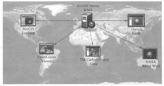
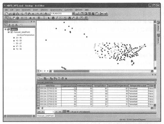
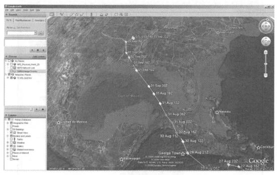
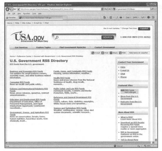
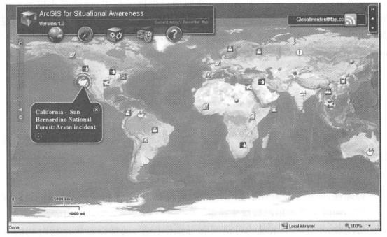
Interoperability is often involved in large projects or national information platforms. Interoperability is to allow software and data from different manufacturers to work together, and the main way to achieve interoperability is to develop standards. The standards of Web services are essentially to specify the specific format of requests and responses, such as what parameters are included in the request, what type of each parameter is, and what results are included in the return information of the response. This section describes standards for Web services, including WMS, WMTS, WFS, WCS, WPS, CSW, and Web service-related standards, including KML and GeoRSS. Interoperability means allowing software and data from different manufacturers to work together. To put it bluntly, I can call your data and functions, and you can call my data and functions. The implementation technology of GIS interoperability has gone through multiple stages (Figure 3.11). Fig. 32 The technology of implementing GIS interoperability mainly goes through stages such as file format conversion, direct-read plug-ins and Web service standards # Early interoperability often involved the conversion of data, such as converting data from one software product into the data format of another software product, or defining a standard file format. Different software products needed to be able to input and output this format. Later, interoperability adopted the technology of plug-in interface, that is, a plug-in was installed in one piece of software. This plug-in could be used to directly read and write data in other software formats in one piece of software, avoiding data transfer and transfer. In recent years, interoperability technology has gradually shifted to the level of Web service standards. This approach not only avoids the transfer of data formats and the trouble of installing plug-in tools locally. Different manufacturers can independently develop their own products based on industry Web service standards. As long as the Web service interfaces of their products meet certain industry standards, the data and functions of their software are called to each other through Web services to achieve interoperability ( Fig. 33 )。 Fig. 33 Interoperability relies on standards. Taking OGC’s WMS standard as an example, a WMS online map service released by ArcGIS for Server can be used not only by Esri products, but also by clients that support WMS standards such as GoogleEarth, NASA WorldWind, OpenLayers, and Gaia. Every client knows what parameters should be sent in the request and can expect what format the server will have in its response. (Thanks: National Park Service) # There are mainly the following standardization organizations for geospatial Web services. It was established in 1994 and currently has more than 400 members, including companies, scientific research institutes, high schools and government agencies from different countries and regions. Enable geographical information to be seamlessly applied to a variety of Web, wireless, location-based services and mainstream information technology applications. This section will introduce OGC’s WMS, WMTS, WFS, WCS, CSW, WPS, etc. Web services specifications and related KML and GeoRSS specifications. IS0/TC 211(International Organization for Standardization Technical Committee on Geographical Information 211) : IS0/TC211 is a technical committee established by the International Organization for Standardization in 1994 to develop geospatial information standards. The standard numbering established by TC 211 starts with 19101. Generally speaking, ISO standards are more abstract, while 0GC standards are relatively more specific. In recent years, IS0/TC211 has worked closely with 0GC, for example For example, the WMS standard for 0GC is also an ISO standard. W3C(World Wide Web Consortium): The W3C is an organization engaged in standardizing information technology on the World Wide Web. It was founded in 1994 at the Massachusetts Institute of Technology’s Computer Science Laboratory by Tim Bemers-Lee, the father of the World Wide Web. The World Wide Web Consortium has formulated a series of specifications, including HTML, CSS, XML Schema, RDF and SVG, which have widespread impact. The Basic GeoRSS specification developed by the W3C, although slightly outdated, is still in use. This section mainly introduces 0GC’s WMS, WMTS, WFS, WCS, CSW, WPS and OpenLS standards. Readers can visit the OGC official website ( http://www . opengeospatial.org) Review the detailed documentation of these specifications to see which WebGIS software is 0GC certified and which standards are supported. WMS is a Web service specification formulated by 0GC for making maps on the Internet. Maps produced by WMS are generally presented in image formats, such as PNG, GIF or JPEG. Any Web service that claims to comply with the WMS specification must support the following two necessary requests: GetCapabilities: Returns description information of the Web service to the client. The format of the result is XML, which describes the service’s name, profile, keywords, coverage, which data layers it contains, what coordinate system each layer has, what attributes it has, and whether it can be queried. This metadata also includes the map image file format that the service can generate, the supported operations, the URL of each operation, etc. For example, using the following URL request, you can get the description information of the land and ocean meteorological WMS service published by N0AA. http://howcoast.noaa.gov/Wms/com.esri.wms.Esrimap/obs ? service = wms&version =1.1 .l&request = GetCapabilities GetMap: You can create a map based on the client’s GetMap request parameters. The parameters required in the GetMap request include which layers to display, the number of pixels in the map, and the spatial coordinate system. Some WMS also support styled layer descriptors (SLD), allowing users to dynamically specify the display symbols of each data layer in URL requests. The returned results are generally images in raster formats such as PNG, GIF, and JPEG. For example, the following GetMap request allows the above-mentioned N0AA meteorological WMS service to generate a map in PNG format. http://howcoast.noaa.gov/Wms/com.esri.wms.Esrimap/obs ? SERVICE = WMS &REQUEST = GetMap&FORMAT = image/fc>ng&TRANS PARENT = TRUE&STYLES = AVERSION = 1.1.l&LAYERS = RAS_GoES_I4,RAS_GoES,RAS_RIDGE_NEXRAD, 0BS_MAR_SWHFT, 0BS_MAR_SSTF, o BS_MET_VIS, o BS_MET_PRES, o BS_MET_WIND, o BS-MET_DP,OBS_MET_TEMP&WIDTH = 1354&HEIGHT =968&SRS = EPSG:102100&BBOX = -10958012 .374959987, 3324093.486064869, -7646148.81342075,5691806. 8742258595 The WMS specification also defines several optional requests, such as The WMS specification is widely used and is adopted by many organizations. For example, the U.S. Geological Survey (USGS) provides a series of WMS services, including the National Map WMS service (Figure 3. 13), National Atlas Transportation WMS Service, National Hydrological Dataset WMS Service, and U.S. real-time fire (mainly refers to mountain wildfires) WMS Service. NASA’s Earth Observation System of Systems (NEO, http://neo.sci.gsfc.nasa.gov/Search.html)WMS ( http://neowms . sci. gsfc.nasa.gov/wms/wms) and other methods to dynamically provide multi-time series images mainly about global climate and environmental changes, including sea surface temperature, land surface temperature, vegetation index, precipitation, carbon monoxide concentration, surface cover type, and solar radiation received by the surface. Fig. 34 Display the land and ocean meteorological WMS service released by NOAA in the ArcGISOnline map browser. (Acknowledgement: National Oceanic and Atmospheric Administration) # WMTS is a Web service specification formulated by the OGC for publishing tile maps. WMTS is different from WMS in that the two complement each other. WMS mainly belongs to dynamic map services, that is, maps are generated immediately by the server every time it receives a customer request. It is especially suitable for map services where data is constantly updated. WMTS maps are pre-made tiles by the server. This method can improve the performance and scalability of Web services, and is especially suitable for data with relatively static data, no longer updated, or very low update frequency (Zhou Xu and Zha Zhuhua, 2010). The WMTS specification defines two necessary operations and one optional operation. GetCapabilities: Get metadata about the service. GetTile: Get tiles. GetFeaturelnfo: Optional, it obtains the information of the selected feature. WFS is a Web service specification formulated by 0GC to operate vector geographical elements and data on the Internet, including retrieval, insertion, update, and deletion (0GC,2005). WFS defines the following main operations. GetCapabilities: Get metadata about the service. DescribeFeatureType: Gets the structure of the feature types supported by WFS. GetFeature: Gets the geographical features and their attributes that match a query criterion. LockFeature: Requests the server to lock one or more geographical features during a transaction. Transaction: Requests the server to create, update, or delete geographical features. The above operations are mandatory and optional. Based on the operations supported, WFS can be divided into the following two categories. Basic WFS: It only supports GetCapabilities, DescribeFeatureType and GetFeature operations, and can only query and read features, so it is also called read-only WFS. Transactional WTFS(Transaction WFS or WFS-T): In addition to operations supported by basic WFS, transaction operations are also supported. It not only supports reading geographical elements, but also supports online editing and processing of geographical elements. It is also known as read-write WFS. In WFS requests and responses, the information transmission of geographical elements mainly uses GML format. In 2006, OGC adopted the GML Simple Features Profile to speed up WFS requests and responses and simplify the difficulty of WFS implementation. WFS can be used not only for mapping and querying, but also for cutting, projection conversion and online downloading of geographical data. For example, the National Weather Service Meteorological Research Laboratory provides a National Digital Weather Forecast Database (NDFD) WFS service (Figure 3.14). This service allows the public, government agencies and enterprises to obtain data such as temperature, dew point, wind, precipitation probability and precipitation. Web Coverage Service (WCS_Web Coverage Service) WCS is a Web service specification formulated by 0GC to publish raster geographical data. It returns Fig. 35 Display the National Digital Weather Forecast Database WFS service provided by the Meteorological Research Laboratory of the National Weather Service in ArcMap. (Acknowledgement: National Weather Service) # Raster data is raw data (mw data), such as ground elevation values in digital elevation and spectral values in satellite images.^ WCS is different from WMS because WMS returns visualized pictures that have lost their original values. The difference between WCS and WFS is that WFS is for vector data, while WCS is for raster data. The WCS specification specifies the following operations (OGC, 2006b): GetCapabilities: Returns metadata for the service. DescribeCoverage: Returns detailed description information of the raster data layer in the service, such as time information, coverage, coordinate system, and supported output formats. GetCoverage: The server returns data in formats such as GeoTIFF, HDF-EOS, or NIT based on the data layer, spatio-temporal range, coordinate system, output format, interpolation method, and data cutting and conversion operations specified by the client. The National Ice and Snow Data Center (NSIDC) provides a WCS service for the polar cryosphere. Users can obtain data on ice areas, including monthly ocean ice and concentration areas, snow cover, and snow and water isobath to support research on polar ice cap melting and climate change (Maurer, 2007). Web Processing Service (WPS-Web Processing Service) WPS is a Web service specification provided by OGC for geographical analysis on the Internet (OGC , 2007c). It defines the format of the input and output (i.e., requests and responses) of geographical analysis services, as well as how clients request the execution of geographical analysis. The geographical data required by WPS can be transmitted through the Internet or it can be data already on the server. The main operations defined by WPS are GetCapabilities, DescribeProcess, and Execute. (6)Other Web service standards CSW-Catalog Service for Web: Catalog services are an important technology for sharing geospatial information. CSW supports searching and publishing geospatial metadata. It allows users to query metadata to discover the geographical data and services they need, and also allows providers to publish and update metadata. There are two types of CSW: read-only CSW and transactional CSW. Read-only CSW supports operations such as GetCapabilities, DescribeRecord, GetRecords, GetRecordByld, and GetDomain, and only supports query and reading of metadata. Transactional CSW supports reading and writing of metadata, allowing users to publish, edit, and delete metadata through transaction and harvest operations (OGC , 2007b). Products such as ArcGIS Geopartal Server provide a CSW interface. OpenLS-Open Location Service: This is a series of Web service specifications provided by 0GC for location-based services (LBS; see Chapter 5), including yellow page search, tracking mobile phone users ‘location, and navigation services (0GC,2004). SWE-Sensor Web Enablement: The SWE framework includes a series of Web service standards: Sensor Observation Services (SOS ), Sensor Planning Services (SPS), and Sensor Alarm Services (SAS). These standards enable users to discover and obtain information from sensor networks. Sensor data. This section mainly introduces the KML specification and GeoRSS specification. KML is a mixed format of geographical data and map description, and GeoRSS can be regarded as a geographical data format. Although they are not Web service specifications per se, in practical applications, they are often used as the format for some Web services to return results. For example, a map service published by ArcGIS Server can return results in KML format, making it available to clients that support KML such as Google Earth. KML Is an XML-based file format from Google and 0GC that describes geographical elements and their visualization. KML was originally created by Keyhole and is the file format used by its EarthViewer 3D. Keyhole was acquired by Google in 2004, and its EarthViewer 3D was renamed GoogleEarth. Google applied to 0GC to use KML as a standard. After demonstration, modification and approval by 0GC members, KML officially became an official standard of 0GC in 2008. A KML file can describe some geographical elements, such as points, lines, polygons, images, and 3D models, and can define their display symbols and camera positions (i.e., the location and height of the observer, the direction of the line of sight, and the angle of looking down or looking up). KMZ files are compressed KML files, which can reduce the size of the file on the one hand, and can contain other types of files such as pictures required for symbols and links in KML on the other hand. Here is a simple example of KML. It first defines a style with a specific icon, then defines a place name annotation and uses this icon to display it. KML It is often used for public information release. For example, the U.S. Geological Survey uses KML to release near-real-time earthquake information, and the National Oceanic and Atmospheric Administration uses KML to release weather forecasts, including severe weather warnings, radar images, and sensor observation data. Figure 3. 15 shows the hurricane’s path in KML format using Google Earth. Fig. 36 Google Earth shows KML of the path of Hurricane Gustav in 2008. (Thanks: Google, LeadDog Consulting, Tele Atlas North America, Inc., Scripps Institution of Oceanography, National Oceanic and Atmospheric Administration, U.S. Navy, U.S. Geospatial Intelligence Agency, General Bathymetric Chart of the Oceans, and Europa Technologies) # RSS is the abbreviation for Really Simple Syndication and is also known as Rich Site Summary or Resource Description Framework Site Summary. It is a major format for publishing information on the Internet, especially useful information such as news and fire bulletins. The RSS family includes RSS and ATOM formats. The former appeared in 1999 and the latter appeared in 2003. They are all simple XML formats with only a few tags to describe the name, summary, full-text link and release time of each piece of information. They are very easy to understand and use, and are widely used. Subscribers can “aggregate” multiple RSSs that they are interested in into RSS reader software, providing them with a convenient “one-stop” service without having to go to various websites to check whether they are updated over and over again. RSS is used by many news media, social networking sites and official government websites as a way to publish new news. For example, CNN, the New York Times, Reuters, Science magazine, Twitter, and YouTube all use this technology to publish information in a timely manner. The World Health Organization (WHO) publishes the latest epidemic and infectious diseases in RSS format ( http://twitter_com/statuses/user-timeline/14499829.rss ); the U.S. government publishes thousands of RSS on its e-government portal ( http://USA.gov)(Figure 3. 16); Using RSS, the Federal Emergency Management Agency publishes news and pictures related to emergencies; the U.S. Census Bureau publishes news related to current demography; and the Centers for Disease Control and Prevention publishes the latest disease morbidity and mortality reports. Fig. 37 RSS is a way to publish real-time information. Thousands of RSS links are available on the U.S. government portal USA. gov. These RSS are provided by departments such as business, economics, health, public security, technology, environment, energy, agriculture, housing, and weather. (Thanks:USA.gov) # With the popularity of RSS, people want to be able to see not only what happens, but also where events happen. GeoRSS is a standard for adding location information to RSS and other XML (OGC, 2006c). GeoRSS comes in three formats: W3C Geo, OGC GeoRSS-Simple, and GeoRSS-GML. W3C Geo: Only point-like features can be described, using WGS84 latitude and longitude coordinates. Although this standard is still in use, it is an outdated standard and is not recommended. (Including feature type, feature name, relationship label, elevation, and radius). Indeed, GeoRSS-Simple’s design is concise and clear, and its coordinate reference system is usually WGS84 latitude and longitude. If the coordinate reference system is not marked, the coordinates default to WGS84 latitude and longitude, but this specification allows the definition and adoption of other coordinate systems. By extending RSS, GeoRSS has become a concise format for requesting, sharing, and integrating geographical information on the Web. GeoRSS is supported by ArcGIS Explorer, ArcGIS Viewer for Flex, GoogleMaps, Microsoft Bing Maps, and OpenLayers. GeoRSS is also commonly used in Mashup applications. Here are some examples of GeoRSS applications. Twitter provides near-real-time GeoRSS information of “who said what and where happened”, allowing users to display these microblog content on a map. Flickr Online Albums provides a REST interface that returns photo information for a given area in GeoRSS format. For example, the URL http://api.flickr.com/services/feeds/geo/United+States/Califomia/Hollywoocl can return photo information for the Hollema area in the United States. The Global Disaster Warning and Coordination System ( http://www.gdacs.org ) provides a near real-time GeoRSS feed to report timely on ongoing natural disasters around the world, such as earthquakes, tropical hurricanes and floods. The USGS uses GeoRSS format to broadcast earthquake information (11 Du 0://63111^1^6.1^3.§ 0 ¥/631111-earthquakes/catalogs/eqs7 day-M5. xml)。Among them, earthquake data for California is updated every few minutes, and every half hour for the rest of the world. GloballncidentMap.com provides a series of real-time GeoRSS feeds that include child abduction alerts, dangerous goods status, terrorism and other threats (Figure 3.17). Fig. 38 GloballncidentMap.com provides a series of events related to public security and terrorist threats in GeoRSS format. This example uses ArcGISViewer for Flex to display these events and their locations. (Note: There are many intelligence sources, making it inconvenient-obtaining permission, this picture is a copy; thanks:TmnsitSecurityReport.com and the National Park Service) # GIS product and application developers want standards to be simple and easy to use, but standardization bodies often need to consider multiple situations. The standards formulated in this way are more inclusive, but they often make standards too complex to be adopted. Sam Bacharach (2006) of the OGC used the following analogy to explain the need to simplify the GML(Geographical Markup Language) standard: “Have you noticed how children use 64-color crayons? Some children can paint by just detecting red, blue, green, yellow, black and other colors. These colors are easy to use, and although they are not many, they already provide a solution to the problem enough to paint a picture of a puppy playing in the backyard swimming pool.” This metaphor not only explains the importance of simplifying GML, but also explains one of the challenges faced by standardization bodies in balancing simplicity and ease of use with completeness and comprehensiveness. In addition, the industry hopes that standardization bodies can formulate standards as soon as possible for adoption by the industry. Standardization agencies have their own cautious work processes. From formulating directions, inviting proposals, submitting drafts by project teams or members to reviewing, revising and voting by members, it takes a certain amount of time to formulate a standard. This often leads to lag in standards. When the standard was released, different manufacturers had developed their own solutions, which were not compatible with the standard. These manufacturers also needed to invest additional people to make some modifications to the product or write some transfer programs to achieve support for the standard. The importance of standards is beyond doubt. Especially in government project bidding projects, bidding products are often required to support international standards to achieve openness and scalability of the system. The OGC website lists the product manufacturers, software names, and the names and versions of the supported OGC standards (see http://www.opengeospatial.org/resource/products/compliant ).Web service-based interoperability #

Standards for Web Services #
Web Map Service (WMS -Web Map Service) #
GetFeaturelnfb
: Query information about a certain location on the map. The typical application situation is that the user clicks on a point on the map, and the server returns the coordinate information and attribute information of the geographical element located at that point.
GetLegendGraphic
: You can create and return a legend of the layer based on the layer specified by the client. The return format is generally PNG, GIF, JPEG and other pictures.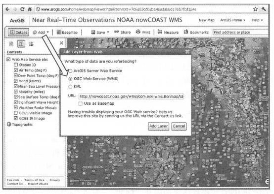
Web Map Tile Service (WMTS) #
Web Feature Service (WFS-Web Feature Service) #
Standards related to Web services #
KML( Keyhole Markup Language) #
<?xml version = "1.0 " encoding = "UTF-8 "? >
<kml xmlns = "http://earth.google.com/kml/2 .2 " >
<Document >
<name > Placemark .kml < /hame >
<Style id = " sh_ylw^>ushpin" >
<IconStyle >
<scale >1.3 < /scale >
<Icon >
<href >http: //Inaps .google .com/fnapfiles Ami/pushpin/ ylw-pushpin.png < /href >
</Icon >
<hotSpot x = "20" y = "2" xunits = "pixels" yunits = "pixels"/>
</IconStyle >
</Style >
<Placemark >
<name> New York < /hame >
<LookAt>
<longitude> -73 .98695099776447 </Longitude >
<latitude>40 .75578596910464 <Aatitude>
<altitude>0 < /altitude >
crange>1838 .244767541828 <々ange>
<tilt >64 .84948240920286 </tilt>
<heading> -0 .00395616889357744 </heading>
</LookAt>
<styleUrl> #sh_ylw-pushpin </styleUrl>
<Point>
<coordinates> -73 .98695099776447, 40 .75578596910464, 0 </coordinates>
</^oint>
</Placemark>
</Document>
<Ami>
GeoRSS #
Challenges faced by standardization bodies #