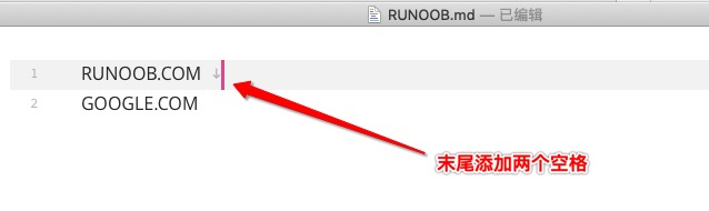
There is no special format for Markdown paragraphs, just write the text directly 段落的换行是使用两个以上空格加上回车 .
Of course, you can also use a blank line at the end of a paragraph to indicate the restart of a paragraph.
Markdown can use the following fonts: The display is as follows: You can set up a separation line with more than three asterisks, minus signs, and bottom lines in a line, and there can be nothing else in the line. You can also insert spaces between asterisks or minus signs. A separation line can be established in each of the following ways of writing: The display is as follows: If you want to add a delete line to the text on a paragraph, you only need to add two wavy lines at both ends of the text. An example is as follows: The display is as follows: Underlining can be achieved through the < u > tag of HTML: The display is as follows: The footnote is a supplement to the text. The format of the Markdown footnote is as follows: The following example demonstrates the use of footnotes: The demonstration effect is as follows: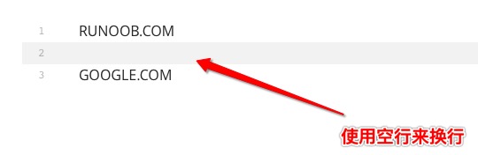
10.3.1. Font 
*斜体文本*
_斜体文本_
**粗体文本**
__粗体文本__
***粗斜体文本***
___粗斜体文本___

10.3.2. Separation line 
***

* * *

*****

- - -

----------
10.3.3. Delete Lin 
RUNOOB.COM
GOOGLE.COM
~~BAIDU.COM~~

10.3.4. Underline 
<u>带下划线文本</u>

10.3.5. Footnote 
[^要注明的文本]
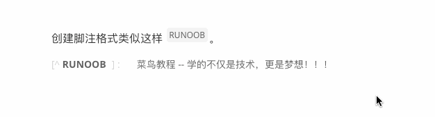
创建脚注格式类似这样 [^RUNOOB]。

[^RUNOOB]: 菜鸟教程 -- 学的不仅是技术,更是梦想!!!