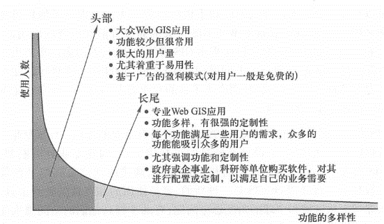
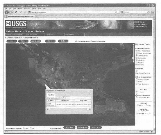
WebGIS has rich functions and can be used in many industries. But at present, the application potential of WebGIS is far from being realized, which means that there are many opportunities in the field of WebGIS. Theoretically speaking, WebGIS can realize all functions of GIS, and can realize the collection, storage, editing, processing, management, analysis, sharing and visualization of geographical information on the Internet. The main functions that are widely used at this stage include the following aspects. Maps and queries: Online maps are the most common form and function of WebGIS. It can be said to be the facade of WebGIS. Each feature on the map has attribute data that can be queried in space (What is this?) and attribute queries (such as where is the bookstore?). Data collection: Professionals and amateur users can use the Internet to collect geographical information. Using mobile clients, field workers can transfer data collected or verified in the field to servers and databases in the office, improving the current nature of the data (see Chapter 5). In recent years, spontaneous geographical information, that is, geographical information spontaneously contributed by non-professionals (Goodchild,2007), has mostly been widely used. Collected through the Web. Dissemination of geographical information:WebGIS is an ideal platform for disseminating geographical information. Government agencies, academic institutions and commercial sectors have long used this platform to share spatial information (see Chapter 6). From the early U.S. spatial data warehouse and geographical information one-stop portal to the current geo. data, gov and ArcGIS.com, etc., all allow users to search and download data, share geographical Web services, promote cross-department cooperation, help users make full use of existing data resources and avoid data re-collection, which not only reduces costs, but also improves efficiency. Geospatial analysis:WebGIS is not only an electronic map, it also provides many spatial analysis functions, especially those important functions that are close to people’s daily lives. For example, measure the distance and area of a feature, find the best driving or bus route, find the location of an address or place name, and use proximity analysis to find the nearest store. Governments, enterprises and scientific research institutions can also use WebGIS to conduct some professional spatial analysis. For example, chemical leak and dispersion models are used to calculate areas that may be affected, and overlay analysis is used to determine blocks to evacuate. In commercial retail, location models can help companies analyze where opening stores may generate the best profits. In terms of low-carbon and green energy, solar radiation models can help the public estimate the energy likely to generate by installing solar panels on their roofs. Based on the distribution of existing crime locations, the public security department can produce a heat map to let the public know where high-risk areas are and remind the public to pay attention to safety. Some of the best path analysis has been further deepened, taking into account not only the distance between the starting point and the end point and the speed limit of the roads along the way, but also the time window required for pick-up, traffic jams along the way, and the height limit of bridges. These functions show that WebGIS can be tailored to actual needs in the real world, providing targeted services to employees, customers and the public, and solving practical problems. WebGIS can be applied in all walks of life related to geography. It has the effects of reducing costs, improving efficiency and expanding influence. This section briefly introduces several application types, and other chapters of this book provide more detailed application cases. WebGIS as a new business model and new commodity WebGIS has created new business models and reshaped many existing business models, directly or indirectly creating huge profits (see Chapter 8). The most significant business model brought about by WebGIS is location-based advertising services. This model is used by Google, Microsoft, and Baidu Maps to display advertising sponsors ‘goods and services based on the keywords and locations searched by users. This advertising method is more accurate and has a higher return rate than traditional advertising models such as TV and radio. From the perspective of advertising sponsors, this pay-per-click model allows them to better understand the actual effectiveness of advertising and better control their investment in advertising. As we all know, this business model has brought huge wealth to companies such as Google. Through the software-as-a-service business model, WebGIS itself can also be provided and sold as a commodity. For example, Esri’s Business Analyst Online (BAO) is a WebGIS-based commodity (see Chapter 8) that uses business analysis models to help users conduct trade zone analysis, store location and search for the distribution of potential customer groups based on large and detailed business data such as population and consumption. BAO charges based on usage, and users can also order annually. By adopting this software-as-a-service business model, small and medium-sized enterprises can also use GIS. They can conduct the business analysis they need without purchasing their own GIS hardware, software and databases, so as to obtain business reports with both pictures and texts., and use this to make business decisions. Many companies use WebGIS for strategic planning, marketing, customer service and daily management in order to improve efficiency and gain competitive advantages. In the past, only a few large companies with desktop GIS and GIS professionals could conduct these GISs analysis. Now, more and more companies, including many small businesses, can use GIS. The user interface of WebGIS is easy to use and can be directly operated by managers, ordinary employees and customers. Almost all commercial websites have pages such as “Store Find” or “Branch Find”, which display their location in the form of a map, helping customers quickly find the store they want to go to and get driving or bus directions. Water companies can integrate WebGIS and CRM(customer relationship management) databases to mark customers who complain about insufficient water pressure at home on maps, analyze where pipelines may have problems, find locations that need maintenance and valves that need to be closed, and send this information and maps to the mobile phones of field maintenance personnel to solve these problems as soon as possible, so as to obtain better customer satisfaction. Federal Express uses WebGIS to track vehicles in real time and monitor conditions inside the vehicle, such as whether the temperature is within the appropriate range needed to store perishable items, to ensure timely and intact delivery (Mollenkopf, 2009). WebGIS is a powerful and approachable tool for e-government The term e-government was proposed in the early 1990s, and many countries actively promoted the development of e-government through legislation, supervision and fiscal incentives. Many government affairs are related to location, and geographical location has become the basic framework of government business, making GIS and WebGIS an important part of e-government. Through easy-to-understand online maps, WebGIS is a very approachable communication channel. With its analytical capabilities, WebGIS can provide decision makers with a wide range of geographical intelligence and decision-making assistance solutions. Many government departments that have long used desktop GIS are also turning to WebGIS to take full advantage of WebGIS’s communication and collaboration advantages (see Chapter 9). WebGIS provides many conveniences for public information services. It enhances government transparency by increasing citizens ‘right to know. For example, through online maps, the U.S. Geological Survey releases the latest natural disaster information (Figure I.ID), telling citizens about recent earthquakes, forest fires, hurricanes, floods, etc., and warning citizens to avoid upcoming disasters. In order to allow the public to understand the operating status of the state government, the Maryland government in the United States has established the MDiMap (Maryland’s Internet Map) website to provide citizens and civil servants with a variety of information, such as planned open spaces, ecological reserves, progress of highway landscaping projects, etc.(see Chapter 9). In accordance with the Megan Act, the U.S. federal government and many states disclose the addresses and personal information of offenders with criminal convictions on the Internet for public inquiry and protective measures to avoid many cases. Fig. 10 The U.S. Geological Survey’s maps website displays natural disaster information in a timely manner, informing citizens of the latest disaster information such as earthquakes, forest fires, flood warnings and storm warnings. (Acknowledgement: U.S. Geological Survey) # Combined with the “crowdsourcing” model, WebGIS is also a bottom-up information channel that can attract public participation, collect public suggestions, absorb collective wisdom, and improve the quality of government work. For example, the U.S. Bureau of Land Management and the Forest Service have used WebGIS to use public knowledge to improve the quality of government planning by asking citizens to mark on online maps that they support or oppose a land-use plan. CitySourced provides municipal facility monitoring services in multiple cities, allowing the public to report issues such as street lights that need replacement and road damage that need repair through mobile phones. WebGIS serves as the basic platform of digital scientific research (e-Science) Modern scientific research often involves massive amounts of data and intensive computing. Grid computing is often regarded as the main platform for digital scientific research. However, grid computing requires complex middleware and has a high learning threshold, making it difficult for most researchers to have the opportunity to use it directly. WebGIS and cloud computing provide digital scientific research with powerful computing power, rich data, low cost, and easy-to-use infrastructure. At present, the World Wide Web has increasingly become a huge distributed database, a powerful computing platform and a collaborative laboratory. The number of sensors and real-time data sets connected directly to the World Wide Web continues to grow. More and more organizations are publishing their map services and spatial analysis services to the “cloud”. According to their own scientific research needs and using aggregation technology, scientists can integrate these rich resources to support their own research. The World Wide Web is already becoming a new platform for digital research that is easy to get started and has obvious results (Hall, De Roure and Shadbolt, 2008). WebGIS is an important tool in people’s daily lives The “six ho” methods (the five “W” and one “H” in English)-who, what, when, where, why and how are basic problems encountered in people’s daily lives, of which “where” is an important aspect. People often encounter problems such as where to eat, where to live, where to shop, and how to get from here to there, all of which are related to GIS. Traditionally, the education community believes that a person needs to learn three basic skills to survive in society, namely “3Rs”~-reading, writing and arithmetic. Recently, spatial cognitive ability has been considered to be the fourth “R” after the “3Rs”, the fourth basic ability (Goodchild, 2006). WebGIS, especially online and mobile maps, is an important means for people to understand their living space and gain spatial cognitive abilities. Long tail theory is a way to analyze Internet business models and opportunities (Anderson, 2004, 2006). According to the long tail theory (Figure 1.12), the head of the long tail curve is the mass market, and the head of the long tail curve is the mass market. Fig. 11 Long tail theory reveals different markets and business models for WebGIS # The tail is a specialized market, and the market profits of the head and tail can be the same. Take music stores and bookstores as an example. Some stores only sell the most popular records or books. Although they offer a small variety of products, each product can sell a large number of products, making it profitable. They occupy the head of the long tail curve. Business models such as Amazon Bookstore take advantage of the long tail effect of the Internet, that is, many of the records and books they sell are not popular products, and the sales volume of each product is not large. However, due to the large variety of products, the total sales and profits add up. Still considerable, which is one of the important reasons for the success of shopping websites such as Amazon. Long tail theory can also be used to analyze business models and opportunities for WebGIS (BOUwman,2005). Head: In the WebGIS market, the head of its long tail curve is occupied by applications such as mass online maps, location-based services, and location-related Social networks. Representative companies include Google Maps, Microsoft Bing Maps and Foursquare. They provide limited but commonly used functions, such as electronic maps, surrounding queries, point-of-interest queries, address matching, best path calculation and finding nearby friends. Due to the large user base, they generally adopt the advertising operation method, that is, they provide free services to users and charge advertising sponsors. Tail: Governments, companies and research institutions often have special needs, including collecting their own specialized or confidential geographical data, providing unique business functions to customers or employees, business exchanges within departments and between organizations, and providing support for corporate operations and decision-making. These special and diverse needs are often not met by mass online map applications and require unique solutions. These solutions are usually completed by each unit itself or with the help of consulting companies by customizing or re-developing professional WebGIS software. Professional WebGIS software can be deeply customized on the server and client sides. Potential markets and opportunities: Currently, WebGIS is still in its early development stage. There are a large number of blank areas to be explored and developed in both the mass market and the specialized market, and these two markets can complement each other. Mass online maps and mobile applications provide geographical visualization and commonly used analysis functions for the general public, demonstrating the huge commercial value and wide application scope of WebGIS. As spatial cognitive capabilities grow and awareness of the potential of WebGIS, people will gradually raise more profound geospatial-related questions (Dangermond, 2009b). These problems often require professional WebGIS to solve, which creates new professional needs and brings new opportunities to the long tail, or professional WebGIS market. GIS professionals play an important role in developing the potential of WebGIS. GIS professionals shoulder tasks such as providing authoritative geographical information, designing high-quality visualization tools, building professional analysis models, making WebGIS an organic part of their own business systems, and building a geographical information sharing platform. In terms of education, WebGIS is a new, easy-to-use and interesting teaching tool that trains students to think from regional and global perspectives, helping to improve their spatial thinking abilities and solve real-world problems (Kerski,2007). Today’s students are tomorrow’s decision makers, GIS designers and GIS users. Cultivating their spatial cognitive abilities is of great significance and can influence the making of many decisions in future society. The 19th century was the century of railways, the 20th century was the century of highways, and the 21st century was the century of information highways. As the World Wide Web continues to grow and popularize, the application and influence of GIS will continue to expand. WebGIS will continue to develop rapidly, penetrate into all aspects of people’s work and life, and make great contributions to the development of human society.function #
application brief #
development opportunities #