Tags are used to display static content, including a single line or lines.
Important attribute
TextAlignment
TextColor
Text
NumberOflines
LineBreakMode
9.12.1. Add a custom method addLabel 
-(void)addLabel{
    UILabel *aLabel = [[UILabel alloc]initWithFrame:
    CGRectMake(20, 200, 280, 80)];
    aLabel.numberOfLines = 0;
    aLabel.textColor = [UIColor blueColor];
    aLabel.backgroundColor = [UIColor clearColor];
    aLabel.textAlignment = UITextAlignmentCenter;
    aLabel.text = @"This is a sample text\n of multiple lines.
    here number of lines is not limited.";
    [self.view addSubview:aLabel];
}
Update the viewDidLoad in ViewController.m, as follows:
- (void)viewDidLoad
{
    [super viewDidLoad];
    //The custom method to create our label is called
    [self addLabel];
    // Do any additional setup after loading the view, typically from a nib.
}
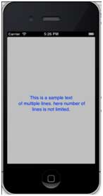
Output 
Run the application and you will get the following output: