Contribute geospatial data #
The government will still play a key role in the construction of the new generation of NSDI, especially in countries where surveying and mapping are strictly controlled by the government. Government departments at all levels hold a large amount of authoritative information. For example, the U.S. Department of Transportation holds real-time traffic information; the Centers for Disease Control and Prevention holds up-to-date information on the distribution of infectious diseases; the Department of Homeland Security holds information on the distribution of terrorists and their targets; the National Weather Service has weather information for monitoring and prediction; The Geological Survey records real-time earthquake and other natural disaster information; the Census Bureau holds a large amount of national demographic data; and the Bureau of Labor Statistics records the purchasing habits of U.S. consumers. Local government communication Fig. 86 Many government departments share their data through Web services. This is Geo. Data,gov portal lists some Web services published by U.S. federal departments, covering basic base maps, meteorology, environmental pollution, soil, hydrology, geology, land use types, etc. (Acknowledgements: U.S. Geological Survey, U.S. National Oceanic and Atmospheric Administration, U.S. Environmental Protection Agency, U.S. Department of Agriculture, and U.S. National Forest Service) # 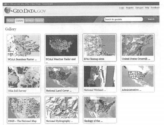
There is often the latest and most accurate data on their local land resources, property taxes and urban planning. These data are also needed for other government departments to work, and the public also has the right to know some information. When the government releases this information, it should try its best to adopt Web services to leave the door for other government departments and enterprises to reuse and secondary development to support their business (Figure 7.5).
NSDI 2.0 will need to bring together as many organizations and individuals as possible to expand sharing and collaboration. Private companies also have a large amount of unique data that government departments do not have or are unmatched, which can also be shared through Web services. Many countries have some large surveying and mapping companies, such as Tele Atlas and NAVTEQ, which have high-resolution ground images and constantly updated street maps; InfoUSA has tens of millions of American company information, including their addresses;Mediamark Research &Intelligence collects information on media choices, product choices, demographics and lifestyles of millions of adult consumers; CMC International has information on traffic flow in the United States, including from highways to rural roads; The Inrix Dust Network tracks approximately 500,000 vehicles on U.S. roads to provide real-time traffic congestion information.
Information sharing can breed more value-added services. When governments make their data open and allow free downloads, other departments can create new services from it (Figure 7.6). For example, the U.S. Census Bureau has released detailed population information across the country, from states, counties, cities to census tracts and block groups (for more detailed comparison, there are 211267 block groups in the United States). Esri in the United States uses this free information, applies economic and statistical models, and derives many new data, including TapestrySegmentation. Fig. 87 An agency can use information provided by other agencies to create new services. Here,Esri creates Web services such as population segmentation, household income, and annual changes in housing prices based on U.S. census data and certain statistical models. (To ft: U.S. Census Bureau) # 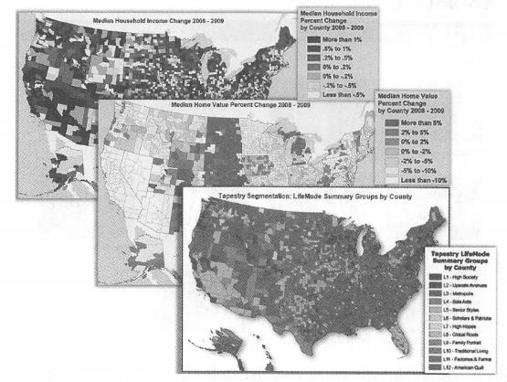
Regions based on indicators such as population income, consumption habits, lifestyle, race and age), forecasts of changes in U.S. household income and housing prices, etc. These Web services can be published in Esri’s ArcGIS Online cloud GIS for use by Esri Business Online Analytics (BAO), Community Online Analytics (CAO), and customers. Academic institutions also collect large amounts of data in project research and create professional analytical models. If these data and models are released into services, they will play a greater role in other researchers and practical applications in society.
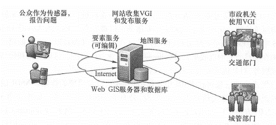
Spontaneous geographical information will play a unique and increasingly important role in NSDI. In the first ten years of NSDI, there was a lack of effective means to collect spontaneous information, and the public was viewed in NSDI’s data collection. “’%^>2.0 “facilitates the participation of users and promotes a large number of ¥ 01. For example,’«^1^Ka has more than 17 million places marked and described by the public and is the world’s largest database of place names. Online photo albums such as Flickr, Picasa and Panoramio have tens of millions of geographically located photos that vividly showcase scenes and events around the world. OpenStreetMap allows the public to upload their own GPS data and piece together this data piece by piece to form a detailed road map covering Europe and other regions. Many social media outlets, such as Twitter and Weibo, provide geolocation features that allow users to post information with geographical locations. Some websites provide a mapping feature that allows the public to report on which road they saw a pothole and on which building they saw some graffiti (Figure 7. 7)。These VGIs can be published through Web services and used by other organizations to create new applications. For example, municipal departments can use this information to dispatch workers, arrange road repairs and graffiti cleanup (Figure 7. 8)。This is CitySourced’s business model (see Section 9.2.2). Fig. 88 The public can mark and report non-emergency issues such as potholes on roads and graffiti on buildings on Web maps or mobile phones, and this data can be stored in a database through feature services. (Thanks: AND Automotive Navigation Data and Tele Atlas North America, Inc.) # Fig. 89 CitySourced collects publicly reported municipal issues and publishes them into Web services and Web maps that are provided to relevant city departments so they can quickly resolve them # 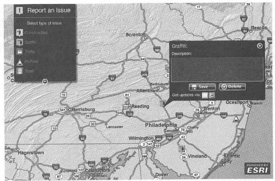
Framework services and specialized services #
In accordance with the tenet of WOA/SOA, Web services should be aligned with business functions to create services with practical needs and support maximum sharing. When a department considers what kind of Web services to release, it should not only consider the internal needs of the department, but also often consider the needs of other external departments and the public. Table 7.1 describes one way to assess these needs. By creating such a table, a city can list the Web services needed by its different departments and other external departments. These Web services can be classified into general, broad needs, and individual needs levels. In the table, Web services A and B are needed by all units and belong to the general level;Web services C, D and E are needed by most departments, so they belong to the extensive need level;Web services F, G and H are only needed by some units and belong to the individual need level. This needs assessment can help an organization analyze what services need to be released, their priority levels, which department created them, which departments are related to, and even how to raise funds or allocate costs.
表7.1基于内部和外部需要对Web服务进行分类,如通用、广泛需要和个别需要等级别
departments | Web service | ||||||
A | B | C | D | E | F | G H | |
urban facilities | V | V | V | V | V | V | |
urban planning | V | V | V | ||||
NDRC | V | V | V | V | |||
public security Department | V | V | V | ||||
fire Department | V | V | V | V | V | V | |
health sector | V | V | |||||
urban management Department | V | V | V | V | |||
private enterprises | V | V | V | V | |||
public | V | V | V | ||||
Other units or departments | V | V | V | ||||
classification results | general | extensive needs | individual needs |
NSDI involves many layers of data in a country or region. Among them, framework data is what most institutions and departments need to use and rely on, so it is the foundation of NSDI. Frame data consists of several basic datasets, which represent important geographical features of a country or region. Other datasets need to be developed with them as location references or superimposed with them as background. Frame data needs to cover the entire country and be of sufficient accuracy. The choice of framework data layers should be based on the specific circumstances and needs of each country (Ryerson and Aronoff,2009). Currently, in the United States, frame data covers seven topics: geodetic control, digital orthophoto, elevation, transportation, 7jC documents, administrative boundaries, and cadastral information (FGDC, 2006). In recent years, people have also proposed to add some new topics as framework data, such as wildlife habitats (Dangermond and Miglarese,2009; Campbell et al., 2009), urban three-dimensional elevations (Campbell et al., 2009)and land use and soil (Cmig, 2009). The collection of framework data often requires the participation of many organizations, especially local government surveying and mapping departments. Then, the collected data needs to be forwarded to the higher-level department, and after quality control and splicing, a complete map is formed. These frame layers should be provided to the whole society in the form of Web services to avoid repeated collection and waste of data. Map services for frame data generally need to be cached (tiles) to improve the response speed of these Web services.
Hosting of cloud GIS and Web services #
Publishing and providing geospatial Web services requires certain software and hardware technologies, especially WebGIS servers and smooth network bandwidth. Institutions with conditions can do this, but some departments are unable or unwilling to publish Web services on their own. For example, they do not have these qualifications or do not want to invest too much in software and hardware, or want to avoid the cumbersome work of system management. In this case, they can adopt the cloud GIS approach (see Section 10.1.8) and outsource the hosting of Web services to the cloud GIS provider (Figure 7. 9)。Some departments are unwilling to put the information owned by their departments into commercial clouds considering the security of information, so they can consider establishing their own private cloud.
Cloud computing is an important part of contemporary information infrastructure. It provides a virtualized shared pool of computing resources (such as network bandwidth, server computing power, storage space, other services and applications, etc.) that users can access and pay for on demand. Cloud GIS inherits many advantages of cloud computing and is a new generation. Fig. 90 Organizations that are unable or unwilling to publish Web services on their own can leverage cloud GIS to publish and host geographical Web services # 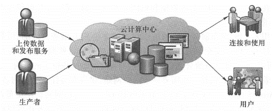
NSDI’s important infrastructure. A large number of Web services can be hosted in cloud GIS, thus providing a foundation for building WebGIS applications. For example, the ArcGIS Online cloud GIS platform provides a variety of basemap and thematic map services in two and three dimensions (Figure 7.10), including images, streets, terrain, water levels, oceans, historical maps, cloud images, population, economic maps, political maps, and Microsoft BingMaps. ArcGISOnline also provides some analysis services, such as address matching, place name lookup, best path analysis, business analysis, and social analysis. Fig. 91 ArcGIS online cloud GIS provides a wealth of 2D and 3D map services and analysis services. (Thanks: ANDAutomotive Navigation Data,Tele Atlas NorthAmerica, Inc., GeoEye, i-Cubed, U.S. Geodetic Survey, U.S. Geological Survey, National Aeronautics and Space Administration, and U.S. Census Bureau) # 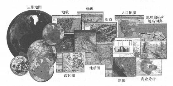
Users can use cloud GIS to host data and services. Take Esri’s ArcGIS Online cloud GIS as an example. Users can upload their data to ArcGIS Online through the ArcGIS desktop or directly use a Web browser, publish it as a service, and host it in the ArcGIS Online cloud GIS (Figure 7.11). Users can also adopt another method, such as purchasing a cloud version of ArcGIS Server, deploying it in Amazon’s cloud, uploading data and maps to this server, and publishing and managing their own Web services.
With cloud GIS, organizations publishing services can gain continuous, reliable access to these Web services. Through the security settings of cloud GIS, these services can be used only by the institutions providing these services, or they can be made public, that is, shared to the public, or semi-public, that is, shared only to some designated institutions. Cloud GIS hosts numerous services and often requires a portal for publishers to register and users to query. For example,ArcGIS Online cloud GIS includes the ArcGIS Portal portal. When a publisher publishes a service, the service is automatically registered in the directory of the portal, and the publisher can also set which user groups have access rights. Users or the public with access rights can inquire, discover and use the service. Fig. 92 Users can upload their data to ArcGIS Online through the ArcGIS desktop (above) or directly using a Web browser (below) and publish it as a service hosted in the ArcGIS Online cloud GIS (Note: The user needs to have permission to publish the service) # 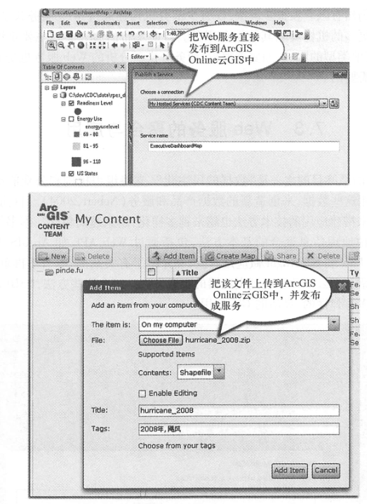
2.4当前地理空间Web服务存在的问题 #
In recent years, the GIS industry has been creating, sharing and using Web services, but there are also some problems:
Many countries still lack complete frame layer services, and some layers have not yet covered the whole country, or the layers are old and poor in current situation, or the resolution is low and cannot meet the needs of today’s society.
Many Web services are difficult to use because their programming interfaces are too complex or do not adhere to industry standards.
Many Web services have poor performance and are unable to support the pressure of multiple users.
Sharing remains limited. In many countries, only a small number of institutions are sharing information through Web services, and more institutions are needed to contribute their data and services. Currently, the main types of services released are map services, and other types of services, such as Web services for model analysis such as feature editing and business, are also very useful and needed.