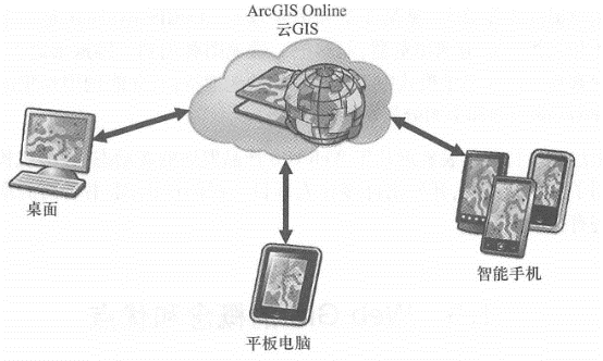
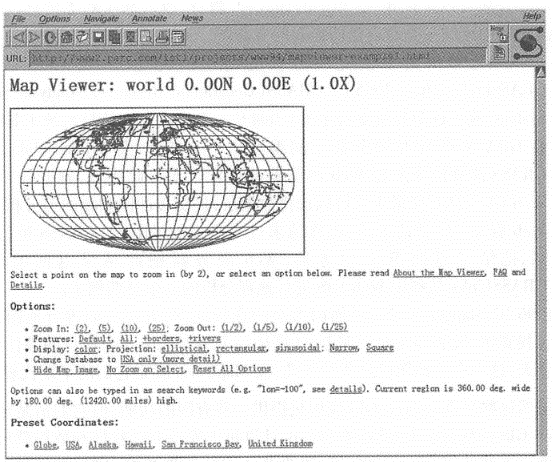
The integration of the Internet, the World Wide Web and traditional disciplines has led to the emergence of many new fields, of which the World Wide Web Geographical Information System is one. Since its inception,WebGIS has developed more and more rapidly, and has largely changed all aspects of geographical information transmission, publishing, sharing and visualization. It is an important milestone in the history of the development of geographical information systems. 1993年,施乐公司帕洛阿尔托研究中心(Palo Alto Research Center,PARC)开发了一个基于Web的地图浏览器(图1.6), 这标志着万维网地理信息系统的产生。 该研究中心在研究基于Web的人机交互时,开发了这个交互式地图网站(PutZ,1994)。 该网站提供了简单的地图缩放、图层选择和地图投影转换等功能。 用户可以用Web浏览器,如当时的Netscape,来使用这个网页,点击页面上的放大、缩小等功能链接, Web浏览器就会向Web服务器发出一个基于 HTTP 的请求, Web服务器则根据收到的请求进行相应的地图操作,制做出一幅新的 Fig. 5 The map browser developed by the Palo Alto Research Center is believed to be the first World Wide Web geographical information system. (Thanks:31 Which 1113? 1112) # Map and send it back to the Web browser, which will receive and display the new map. This website pioneered a method of running GIS in a Web browser, demonstrating that users can use GIS anywhere there is the Internet without having to install GIS data and software locally. This advantage is unmatched by traditional desktop GIS systems. The geographical information system community recognized the above-mentioned advantages of WebGIS, quickly adopted this method, and made many WebGIS applications. For example: In 1994, Canada’s National Map Information Service released Canada’s first online national atlas. It is an interactive map website that allows the public to select some data layers, such as roads, rivers, administrative boundaries and ecological zoning. The server can select the appropriate symbols to make the map needed by users. The public can view online maps at home rather than having to go to government offices in person to apply for maps. In 5, institutions such as the University of California, Santa Barbara developed the Alexandria Digital Liberal (ADL)(Frew et al., 1995), the United States Geological Survey (USGS) led the development of the National Geographic Data Warehouse (Nebert, 1995). These two websites allow users to query the maps, images, or other geographical information they need by keywords or by region. They are examples of early geographical information sharing portals. In 1995, the U.S. Census Bureau released its TIGER (Integrated Topological Geocoding and Reference Format) mapping service, which transformed the huge amount of national population information into online maps for public use. The public can query information such as race, education, income and age about states, counties and cities, and draw and view the thematic maps they need in a Web browser. In 1995, Susan Huse, a doctoral student at the University of California, Berkeley, developed GRASSLinks(Huse, 1995). GRASS (Geographical Resources Analysis Support System) was a desktop geographic information system tool at the time, and HUSe wrote an interface between GRASS and Web servers, called GRASSLinks, that enabled GRASS to accept requests from Web browsers. Based on this interface, she developed a Web GIS applications allow users to select a data layer and submit analysis requests such as buffer and overlay. After the Web server receives the request, it further sends the request to GRASS. After GRASS analyzes it, it returns the results to the Web server, and the Web server returns the results to the user. GRASSLinks is an early example of using WebGIS for geographical analysis. In 1996,MapQuest released online maps for the public, allowing people to browse maps, find hotels, restaurants and other business points of interest, and calculate the best path from one location to another. Today, such online maps are very popular, and MapQuest is an early representative of them. 虽然这些早期的WebGIS应用只提供一些有限的功能, 但它们清楚地展示了 WebGIS的优势:用户不必在自己的计算机上安装GIS软件和数据就可以在任何地方上网使用GIS。 1996年,商业WebGIS软件相继出现,在这些软件的基础上,美国地质调查局 、环境保护署、住房和城市发展部、土地管理局以及许多其他国家的政府、企业和科研等机构,开发出了 WebGIS在很多领域的应用。 Entering the 21st century, especially since the so-called “Web 2.0”,WebGIS has shown some new characteristics. “Web2.0” is a controversial term. It was first proposed by DarCyDiNucci(1999), but people are often closely associated with Tim O’Reilly, mainly because O’Reilly organized the famous Web 2.0 seminar in 2004 and published a paper in 2005 that discussed the characteristics of Web 2.0 in detail (0’Heart %, 2005). The controversy about “Web 2.0” is that it sounds like a new version or new specification defining the World Wide Web, but it is not the case. It just represents some new patterns that have emerged in people’s use of the Web. O’Reilly pointed out in his article “What is Web 2.0” that the Internet bubble burst in the autumn of 2001, but this did not mean a collapse of Internet applications, but marked a turning point. A number of innovative applications have emerged, making the World Wide Web more important than ever. He summarized the development trends in the Web 2.0 era: Bottom-up information flow and crowdsourcing:Web 1.0, the Web before Web 2.0, is mainly characterized by the flow of information from websites to users (i.e., top-down). Web 2.0, on the other hand, introduces a reverse, bottom-up flow of information, thanks to the participation of a large number of users and the rich content they create. The competitive advantage of many Web 2.0 companies stems from the participation of netizens. For example,eBay’s online shopping site comes from the participation of a large number of netizens. The more sellers, the more complete products they have, which attracts more buyers, which further attracts more sellers; Amazon The shopping site encourages buyers to submit reviews on products, which can help other users choose products, so it attracts more users; Blog sites use works such as netizens ‘diaries to attract other netizens; Wikipedia, this is the most comprehensive The latest “Encyclopedia” was compiled voluntarily by thousands of netizens. The World Wide Web has become a new platform for software development: The Web has brought some new developments in software technology, such as cloud computing and Software as a Service (SaaS), providing the resources and software functions of a server or computing center in the form of Web services (see Chapter 3) or Web applications, so that developers can recombine them to develop new and colorful application systems. Lightweight development model: More and more Web applications provide lightweight, simple, often browser-based development interfaces, such as AJAX( Asynchronous JavaScript and XML)-based interfaces. These simple development interfaces greatly reduce the threshold for Web application development. Data is the core: the success of many large Web systems is often based on the unique databases they accumulate, such as the large amount of web content retrieved and stored by Google, the large amount of product information stored by Amazon shopping sites, and the large amount of product information accumulated by eBay. Information on sellers and buyers. Companies can build these databases alone or crowdsource them. When this amount of data accumulates to a certain level, its importance becomes apparent and can provide the company with a unique competitive advantage. Multi-platform clients: People use increasingly diverse platforms to access the Internet. They are no longer limited to the Web browser of desktop computers, but also include traditional desktop applications and mobile devices such as multiple mobile phones. Web application development needs to take care of the clients of these platforms. Rich user experience: Early web pages were mostly monotonous, while those popular Web 2.0 websites often had easy-to-use yet pleasing user interfaces. Formula (1 _ 1)Summarizing the main features of Web 2.0, Web 2.0 makes the Web more interactive and valuable. The geospatial industry, including popular map websites for individual users and professional geographic information system companies for corporate users, has recognized these characteristics and gradually followed these principles, emphasizing user experience, encouraging user participation, providing simple interfaces, and incorporating these principles into its own product Xie Ten Middle School (Maguire, 2008). Web 2.0 = User-contributed content +Web as a development platform + Rich user experience (1.1) Popular online maps, such as Google Maps, Google Earth and Microsoft Bing Maps (formerly known as Virtual Earth), are good examples of Web 2.0 applications. They all provide detailed maps and high-definition images covering many areas. Microsoft’s Hawkey-eye side view aerial imagery shows details of the ground. Google’s Street View and Microsoft’s StreetSide both provide panoramic photos along the street, with ground features such as traffic signs, advertisements and shops clearly visible. These realistic images have aroused people’s great interest. Using these online maps, people can travel around the world without leaving home, or bird’s eye view of cities with high-rise buildings, or soar into mountain cities and lakes, and browse scenic spots and historic sites in various places, such as being immersive. They can also help people find restaurants and hotels and the best driving, walking or bus routes to get there. Their user interface and usage are very user-friendly, and even become as popular as playing video games. Professional WebGIS products, such as Esri’s series of products, also embody the above design concepts to allow people to share, communicate, operate and integrate geographical information on the World Wide Web: Crowdsourcing and data are the core: In the geospatial industry, user-contributed information is called voluntary geographical information (VGI). In order to support crowdsourcing of geographical information, ArcGIS Server provides a featureserve that allows users to collect geographical coordinates, attributes, and related photos and videos and other documents through the Internet. ArcGIS Online is a cloud GIS(Figure 1.7) and a geographic information sharing portal. Users can publish, upload or register their own Web services, data and applications to this portal, quickly accumulating a large number of geographic services, making it convenient for people to develop applications on this platform to further attract more users. Lightweight development model and Web is the development platform: Using ArcGIS Server, government, commercial, scientific research and other institutions can publish their data, maps, and model analysis in the form of Web services. These services have simple, JavaScript, Flex, and Silverlight browser-side interfaces. These interfaces are simple and easy to use, lower the technical threshold required for development, and provide the so-called lightweight development model. People can quickly combine these Web services from different departments and build new applications to meet their own business process needs, which not only reduces costs, but also improves system flexibility. Supports multiple clients such as mobile platforms: In addition to supporting desktop application clients and desktop browser clients, ArcGIS Server also provides mobile applications and development interfaces for multiple operating systems such as Apple iOS, Google Android, Microsoft WindowsPhone, and Windows Mobile. It delivers GIS to field personnel, making it easier for them to browse maps, collect data, and call GIS analytical models to achieve information exchange and collaboration in the field and in the office (see Chapter 5). Fig. 6 ArcGIS Online(ArcGIS.com) is a model of cloud GIS. It is based on Amazon’s elastic computing cloud and provides publishing, uploading, hosting and registering Web services, data and applications. It quickly accumulated a large number of geographical services and can support multiple clients such as desktops, tablets and smartphones # Fig. 7 ArcGISExplorer Desktop Edition is a 2D map and 3D virtual earth browser that can call multiple Web services from ArcGIS Server. In this figure, ArcGIS Explorer calls ArcGIS Server’s geographic analysis service to display the areas that may be affected by the poison gas leak. (Thanks:AND Automotive Navigation Data and Tele Atlas North America, Inc_ ) # Rich user experience:ArcGIS Server provides interfaces based on JavaScript, Flex and Silverlight. These interfaces have fast user interaction capabilities, integrate multimedia and animation effects, and make it easy to create Internet applications with a rich user experience, which can not only improve user satisfaction, but also help users improve work efficiency (see Chapters 2 and 4). ArcGIS Explorer is a 2D map and 3D virtual earth browser that can superimpose 2D maps on 3D terrain, allowing users to explore and discover geographical features that are not easy to see in 2D mode, and can call and integrate ArcGIS Server’s map and spatial analysis capabilities (Figure 1.8). These characteristics represent new trends in the development of WebGIS products in recent years. Many organizations have quickly utilized these new technologies and developed many refreshing applications. Some relevant cases will be introduced in the later chapters of this book.Origin and early application #
recent developments #