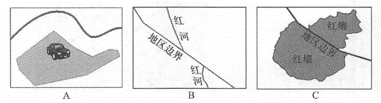
The new generation of NSDI is based on technologies such as Web services, cloud computing, spontaneous geographical information and aggregation. Although there are still some problems that need to be solved in development, this direction is the general trend. (1)Data quality and semantic interoperability Ways to share geographical information through methods such as Web services also face some traditional problems, such as semantic heterogeneity of multi-source data and differences in spatial accuracy. Semantic heterogeneity may be cognitive or naming. Cognitive heterogeneity refers to two organizations having different views on the same object in the real world; while naming heterogeneity refers to naming differences in the same phenomenon in the real world (Bishr, 1998). The result of these isomerisms is that different organizations talk about the same terms may have different meanings, while different terms may actually mean the same thing. Data from different institutions differ in spatial accuracy. Some countries artificially add biases for data confidentiality. Problems often arise when integrating these data with data from other sources. As shown in Figure 7.14, the position of ground vehicles measured using GPS is consistent with lake information from another institution, resulting in a situation where vehicles are driving in a lake; due to inconsistent data accuracy, data from two counties or provinces, such as rivers, do not match where they connect; because two countries or regions have different classification indicators for soil types with the same name, they also do not match in border areas. Fig. 95 When multiple sources of data with different spatial precision or different semantics are put together, the differences between them become very obvious: (A) because of the difference in precision, on the map, a car is driving on a lake;(B) due to inconsistent precision, the same river cannot be connected well on the regional boundary;(C) due to semantic heterogeneity, the same soil type cannot be strictly aligned on the regional boundary # The accuracy of frame map services is particularly important. They are often used as basemaps that people use to locate or collect other information, including professional information and spontaneous geographical information. If the framework data is inaccurate, the data based on it will also inherit these errors, which may be circulated in the information ecosystem and affect the derived application system. For data producers, ensuring data quality and semantic interoperability is very important. Data users should understand the accuracy of the data source and cannot use low-precision data for applications that they are not competent. For VGI, achieving the same level of credibility as authoritative data sources still requires a mechanism to effectively control or verify their quality. For domestic and international standards bodies, developing standards for semantic interoperability remains an important task. Application security and reliability Due to some security and reliability concerns, some organizations are reluctant to convert the data they have into web services or rely entirely on external Web services. They chose a software plus service (S + S) architecture. The software-plus-service model combines the functions provided by Web services and the functions provided by locally running software (Chong et al., 2009). S + S applies to the following situations: Running offline: S + S allows an application to manipulate offline data locally when an application cannot connect or cannot always connect to the Internet. For critical data and functions, it is useful to have a locally installed system or backup. Security considerations: When information is so sensitive that the consequences of a leak are so serious, many organizations prefer to keep the data on their local network rather than upload it to an external network. In addition to the S+S approach, the rise of private clouds can also solve the above-mentioned offline operation problems and meet system security needs in many cases. Business Model: Who pays? Web services bring many benefits to users, but the providers of these services will inevitably have some investment and expense expenses. These costs may be reduced as information technology advances, but they will not be eliminated completely. Some services can recover costs by charging on a per-usage basis. Public welfare services require funding from relevant government agencies. In the long run, using geographical information as a free or low-cost service will achieve intangible benefits. By integrating this information and services, the government can make evidence-based decisions, the public can understand the operations of the government, and business organizations can create value-added products, which will ultimately produce huge social and economic benefits (Welle Donker, 2009). NSDI has a wide range of content and is not the sole responsibility of any one person, nor is there a simple indicator of its success. Therefore, it is not surprising that people have different views on the current results of NSDI and the tasks that need to be carried out next (Longley et al., 2005)。However, few people can refute the benefits of data sharing and reduced duplication and waste that NSDI advocates for sharing and coordination. The first ten years of NSDI’s development were mainly government-centered, with data replication as the main sharing method. The development of Web technology in recent years has provided a set of enhanced technologies that can build a new generation of NSDI. In order to achieve better openness and flexible architecture, the new generation of NSDI should be based on the concepts of Web services and SOA, based on technologies such as cloud computing, aggregation and geo-browsers. The U.S. government has formulated a “Clcmd First” strategy, and the government’s information system construction prioritizes cloud platforms. NSDI 2. 0 Spontaneous geographic information should be supported so that governments, business, academia and individuals can participate in the collection and sharing of geospatial data. The planning and production of its Web services should be oriented to market and social needs ^In this way, the new generation of NSDI will reach a new level of more flexibility, better interoperability and higher effectiveness that NSDI 1.0 cannot achieve. Despite the above challenges in building NSDI 2.0, its value has been clearly demonstrated in many successful projects. It can greatly broaden the fields in which GIS can be applied, lay a solid foundation for the development of e-commerce (see Chapter 8) and e-government (see Chapter 9), and bring a series of new opportunities to the overall development of society.problems to be solved #
Outlook #