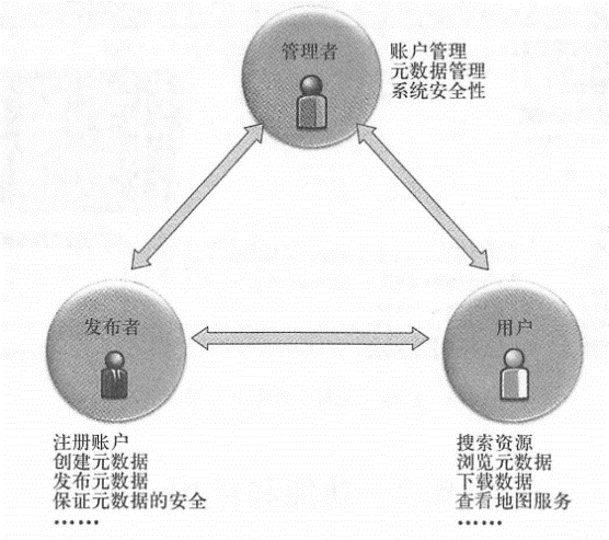
The geographic information portal is based on its metadata catalog. Based on this, geographical information portals provide managers, content providers (publishers) and users with a series of functions. This section combines Esri GeopartalServer and ArcGIS Portal products to introduce the functions and features of modern Geopartal.
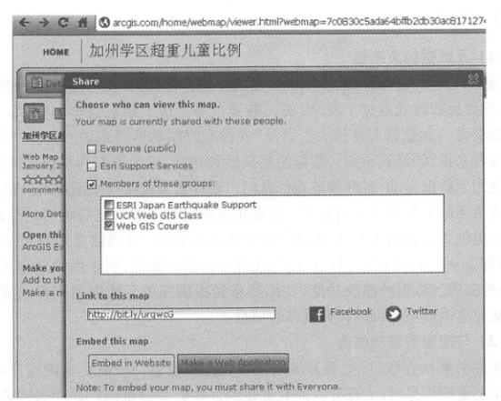
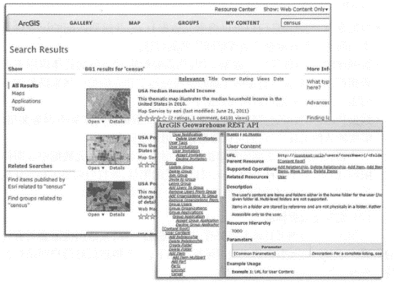
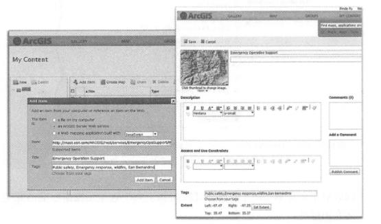
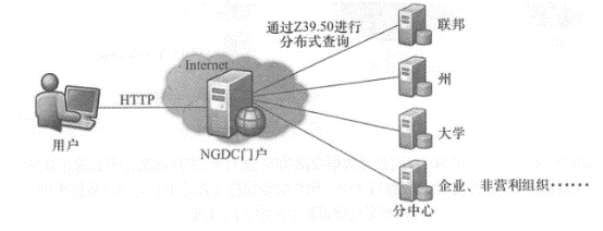
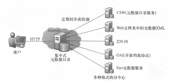
Geopartal Server was released in 2003 and is currently a free open source software (download site is http://sourceforge.net/projects/geoportal/ ). Its users are mainly government departments and are adopted by projects such as the U.S. Geoinformation One-Stop Portal and the European Geoinformation Portal. ArcGIS Portal is a new product that originated from ArcGIS Online( ArcGIS. com) Cloud GIS metadata catalog management system. In the early days, it was a shared portal for the ArcGIS user community. It could be easily integrated with the ArcGIS series of products and was easy to use. It emphasized support for Web services. It attracted the interest of some departments and was adopted by government departments such as the U.S. Environmental Protection Agency and the Department of Agriculture. ArcGIS Portal also became an official product in 2011. Early geographic information portals were mainly for sharing and downloading data. At present, Web services have become an important way of sharing geographical information, and supporting the query and use of geographical Web services has also become an important development direction of geographical information portals. Web services have many advantages as a way to share geospatial information. For users, they can directly use the service without having to purchase software to load data, which is easier; for publishers, they can control the access rights and usage of the Web service, which can better protect intellectual property rights; in addition, the Web service can publish data in real time or near real time, which can achieve better timeliness (see Sections 3.1 and 7.1 for details). Fig. 71 Geographic information portals are aimed at publishers, managers and users, providing them with different functions # Features needed by publishers Create an account: Add certain user groups; Create metadata: You can create metadata that complies with certain standards; Publishing metadata: You can publish metadata to the portal directory; Manage metadata: You can list the metadata you publish, modify and delete them; Protect metadata: Allow publishers to specify whether their metadata is disclosed to all users or shared only to certain user groups; 其他功能:对于那些已经有本单位、本地区或本专题地理信息门户的发布者, 应当提供注册功能,允许他们把自己的门户网站的信息注册到总门户中, 以实现自动的、批量的元数据发布。 Functions required by managers Manage accounts: Browse account lists, create groups, manage user rights, revoke and restore accounts; Manage metadata: Review metadata published by publishers and be able to approve, veto, modify and delete; Other functions: Manage and check the metadata batch harvesting process. Functions required by users (users of information) Create an account; Query metadata: Query and retrieval can be performed based on keywords, content type or format, spatial range and time range, and query results can be sorted and displayed according to relevance or other attributes (Figure 6.5); Reading metadata: You can view the original XML format or the converted, more readable HTML format; Download data: For data that can be downloaded online, you can click on the link to download the data; Preview and use Web services: Ability to preview map services and combine multiple map services; Other functions: Store search criteria, receive email notifications when new metadata meets the query criteria, and store maps you create. Geographic information portal software products not only need to provide the above functions, but also need to provide programming interfaces so that developers can customize or configure them to meet the specific needs of different user units (Figure 6. 5) Fig. 72 The ArcGIS Online portal supports registration, query, result display (left) and aggregation of geographical information resources. It also provides a programming interface (right) to support secondary development # Metadata is “data about data” and a description of entity data. Geospatial metadata refers to information that describes geospatial data, Web services, or other geospatial resources. The importance of metadata for geographic information portals Geospatial metadata, usually stored in XML format, describes information such as “who, when, where, what to do, and why” of geospatial data or other types of resources (FGDC, 2006). Object-level metadata can describe a single data entity, while collection-level metadata can describe a series of entity combinations (Goodchild and Zhou,2003). Geospatial metadata typically contains the following. Data identification: data title, citation, abstract, purpose and keywords; Data quality: data positioning accuracy, data integrity and consistency; Spatial reference: coordinate system and spatial range; Time information: the time of data collection and the effective time range of data content; Distribution information: Information about the distributor’s contact information and how to obtain the data, such as the format of the information resource, downloading the data, or using the URUs of the Web service Metadata plays an important role in data archiving, evaluation, management, discovery, transmission and distribution. Metadata has the following effects on geographic information portals (! ^01^1676131., 2〇05;^111〇08161’0111&11(1213-tanova, 2008) 。 Data discovery: Geographic information portals can search metadata catalogs and return matching records and information on how to access and obtain these geospatial resources. Data evaluation: Once you discover a data resource, you need to determine whether it matches your specific application needs, such as whether it has sufficient detailed spatial resolution and qualified quality to meet the needs of your project? Answers to these questions can be found in metadata. Data utilization: Metadata usually includes dataset file size, data format or Web service type, software tools required, etc., which can help you use these resources. A simple agreement between users and data publishers: Data publishers can indicate usage restrictions in metadata, such as daily limits for a Web service, copyright ownership requirements and scope of liability, which can help avoid and resolve possible disputes. Spatial metadata standards Just as library catalog cards need to have consistent columns, metadata needs to have a unified format. The main international standards for geographical information metadata are as follows. A geographical information portal often supports one or more metadata standards (Figure 6. 6)。 Dublin Core: This is a simple standard for describing multi-domain information resources. This standard was developed in Dublin, Ohio, USA in 1995 and was later established as an ISO international standard by the International Organization for Standardization (ISO). The biggest advantage of this standard is its simplicity and ease of use. It mainly consists of 15 data elements, including title, creator, date, theme, introduction and permissions. Dublin Core metadata is the most widely used metadata standard, but due to its limited elements, it often needs to be extended using the Resource Description Framework (RDF) to support the description of geographical information. The FGDC Digital Geospatial Metadata Content Standard (CSDGM, referred to as FGDC Metadata Standard) was drafted in 1992 by the Metadata Working Group under the Federal Data Commission. then-President Clinton issued an executive order in 1995 requiring all federal agencies to use this standard. CS-DGM is widely adopted in the United States and many countries. The metadata standard has seven main parts, namely identification information, data quality information, spatial data organization information, spatial reference information, entity and attribute information, distribution information, and metadata reference information, with a total of more than 400 elements. It should be noted that the U.S. government is currently moving from the FGDC metadata standard to a North American-specific standard based on the ISO geographical metadata standard. ISO Geographical Metadata Standards: The ISO/TC 211 Technical Committee has developed and approved a series of international metadata standards. The ISO 19115(2003) metadata specification includes 14 parts and more than 400 data elements; the ISO 19139(2007) metadata standard provides a common specification for describing, verifying and exchanging geographical information. ISO standards are adopted by many countries. Based on ISO standards, some countries select some necessary and optional elements from ISO metadata standards and combine them into their own professional standards. For example, the United States, Canada and Mexico have defined North American-specific standards based on ISO 19115 and 19119. Fig. 73 Esri Geoportal Server is a free open source geographic information portal software product. It supports Dublin Core, FCDC and multiple ISO metadata specifications # (3)Metadata 2.0 Most geographical metadata standards are complex, and often more than 60 or even 100 items of information need to be filled in to comply with the minimum standards of FGDC and ISO. Although some software, such as the ArcGIS desktop, can help users create standard metadata, creating standard metadata is still a onerous task that troubles many data publishers and affects the sharing of geographical information. In the Web 2.0 era, bottom-up information flow is already a common phenomenon. For example, people are actively posting videos and photos on YouTube, Flicki, and other sites, thanks in large part to the incredibly simple metadata these sharing sites employ. If these sites require users to fill out dozens to hundreds of metadata items before they can post videos and photos, this will discourage most people from participating and sharing. One implication of this phenomenon for geographic information sharing is that, in order to encourage and facilitate sharing of geographic information, geographic information metadata specifications should be simplified (Hogeweg, 2009b). Goodchild et al.(2008) proposed “Geographical Metadata 2. The concept of “0” believes that new geographical metadata should be user-centered, with simplicity and practicality as the main goal, so that it is easy for contributors to create and users to understand. Recently popular tags and user comments represent metadata 2. 0 (Figure 6.7). Fig. 74 The ArcGISOnline portal uses “Metadata 2.0” style metadata. Publishers only need to provide a small amount of information (as shown in the left) to quickly publish content. Publishers can also edit the metadata (as shown in the right), add more detailed information, and support users to comment on metadata # Tags: Many video, photo and blog sites allow publishers to freely fill in keywords, which can be tags about content, subject, author, time and place, etc. From a professional perspective, this metadata is often informal and incomplete. However, these tags allow users to quickly evaluate whether the resource is what they need. User reviews or ratings: For example, online stores provide users ‘reviews of products. These reviews evaluate the advantages and disadvantages of products from the perspective that the user cares about, and are a unique and practical metadata for other users. Large geographical information portals, such as those at the national and regional levels, usually involve many sub-centers, such as portals of lower-level units or partners. How to integrate with these branch centers involves the architecture of distributed or centralized metadata catalogs. distributed data catalog Geographic information portals that use distributed data catalogs need to perform distributed searches, that is, search multiple subdirectories separately in order to obtain complete results. A typical example is the National Geospatial Data Exchange Warehouse (NGDC ) developed in the United States in the 1990s. It has hundreds of sub-center nodes from federal and state governments, universities and foreign countries. NGDC adopts a distributed directory architecture (Figure 6. 8), Each participant has its own metadata directory and server, called “nodes”, and these nodes are registered with NGDC’s servers. When a user makes a query on the NGDC portal website, he needs to select one or more nodes, and then the server sends the user’s query conditions to the selected nodes, and these nodes perform the query respectively. The query results are merged on the NGDC server and displayed to the user. Fig. 75 Geographic information portals with distributed directories, such as the National Geospatial Data Exchange Warehouse in the United States in the 1990s, require searching multiple subdirectories to get complete results # NGDC is a well-known success case in the construction of spatial data infrastructure. It was once the most important query portal and distribution mechanism for geographical data in the United States. Although successful, it also has some limitations of distributed directories, including Difficult to search globally: Users must select a limited number of hundreds of nodes to query, and those nodes that are not selected often have data that meets user needs. Performance limitations: When multiple nodes are selected for query, it waits until the slowest node responds before combining the results. It is difficult to sort results uniformly: Different nodes have different matching and sorting algorithms, and results that score high in one node may score low in another node. When results from different nodes are merged, it is difficult to maintain consistency in ranking metrics. High requirements are placed on data providers: each data provider needs professional personnel to build and manage sub-nodes. Centralized data catalog With the development of information technology, the performance of databases to store large amounts of metadata and perform full-text retrieval has been greatly improved, and large-scale centralized data catalogs are becoming common and popular. For a large geographic information portal with multiple sub-centers, if each unit already has its own catalog, the general portal website can adopt an automatic harvesting (similar to a web crawler of a search engine) method to collect and store the metadata of the sub-centers to the general center at an appropriate time frequency, such as once a week or once a month. For example, the one-stop geographic information portal in the United States supports this method (Figure 6.9). Fig. 76 Esri GeoportalServer provides metadata harvesting function, which can automatically and regularly harvest and publish metadata from sub-centers to the metadata catalog of the main center. The user’s data search is performed in the catalog database of the main center, rather than searching the catalogs of each branch center # Centralized data catalogs overcome the limitations of distribution and have the following advantages. Easy to conduct global search: Each search is conducted in the directory of the main center, searching all metadata records, and users do not need to select and discard some nodes. Easy to uniformly sort results: Search results are obtained from a database and are easily sorted by relevance or other attributes. High performance: The search is only performed in the database of the main center, and there is no need to wait for the sub-centers to complete the query. Although a centralized catalog may have a huge amount of data, high performance can still be achieved as long as the system is properly designed and optimized. 对数据提供者的技术要求比较低:数据提供者不需要有自己的地理信息门户。 他们的元数据可以放在一个Web上的文件夹里,就可以被收割到总中心的目录中。 The one-stop portal for geographical information in the United States is a representative of a centralized catalog. It has hundreds of sub-centers, such as the U.S. Census Bureau, the Geological Survey, the National Oceanic and Atmospheric Administration, and the National Park Service, all with thousands of metadata records. If they need to publish their own metadata item by item, it will be extremely cumbersome and inefficient. Based on ArcGIS Geopartal Server, the portal allows publishers to register their branch centers (Figure 6. 10), and can automatically and regularly connect to the servers of these sub-centers to collect their metadata. Fig. 77 The one-stop portal for geographical information in the United States allows publishers to register their own branch centers, such as protocol types, connection URLs, and harvesting frequencies. (Thanks:data,gov) # There are different types of geographical information portals. It can be divided into departmental, local, national or global according to level; it can be divided into comprehensive or professional according to theme; it can be divided into categories that focus on online data downloading, focus on Web services, etc. Different types of portals have different characteristics and different design concepts. For example, cross-departmental government portals often emphasize national and international standards, such as ISO metadata standards; while portals within a unit or enterprise emphasize convenience, and the requirements for metadata standards are relatively secondary. Esri Geopartal Server and ArcGIS Portal are two representative geographic information portal products. Both provide programming interfaces and support secondary development; the two have some different characteristics and are suitable for different needs. Given that both products are developing rapidly and their functions are constantly improving, this section provides a brief introduction to them. Esri Geoportal Server Esri Geoportal Server is currently a free open source software (download from http://source-forge , net/projects/geoportal/). Its users are mainly government departments and are adopted by projects such as the U.S. Geoinformation One-Stop Portal and the European Geoinformation Portal. characterized by Emphasis on specifications: Support metadata specifications such as Dublin Core, FGDC,ISO 19115, 19119, and 19139, as well as specialized standards such as Europe and North America (Figure 6. 5), also includes various OGC Web resource formats Support such as WMS. It is convenient to implement a “one-stop” portal, supports distributed catalogs and centralized catalogs, and publishers can register their own branch centers, specify harvesting frequencies, etc. ArcGIS Portal ArcGIS Portal originated from ArcGIS Online( ArcGIS. com) Metadata catalog management system for cloud GIS. It has the following characteristics: Easy to use: Using “Metadata 2.0” style metadata, publishers only need to fill in the title, tag (keyword), description and URL to quickly publish geographical resources. The query method is simple, and the query results are easy to read, preview, and superimpose. Users can comment on metadata to communicate with the owner of the metadata and his communicate with other users. Emphasis is placed on support for Web resources such as Web services: support the registration, query and use of Web services from ArcGIS Server, services from OGC WMS standards, KML, and user-created Web applications and mobile applications. Its map browser supports previewing, aggregation, and customized display of symbols and information windows for these Web resources, and provides templates for users to create Web applications. Related to the ArcGIS family of products including ArcGIS. Seamless integration of cloud GIS: ArcGIS Desktop can directly publish and register Web services into the ArcGIS Portal. Geographical resources in ArcGIS Portal can be used by clients of ArcGIS series products (such as desktop, smartphone and tablet versions, ArcGIS Explorer, and ArcGIS’s JavaScript/Flex/Silverlight interfaces) to conduct query, display and other method calls. Users can upload CSV, TXT, GPX (GPSExchange), Esrishapefiles (compressed zip files), ArcGIS layer files (lyr), map packages (mpk), and layer packages Upk) directly through the browser to ArcGIS.com cloud GIS for users to download and browse Review and aggregate use (see Chapter 7 for details). Security management: Publishers can join existing groups, create new groups, invite other users to join groups they create, and approve or reject applicants who want to join their own groups. Data publishers can choose which group to share each resource they publish with, or to share it with all users (Figure 6. 11)。 Thanks to the above characteristics,ArcGIS Portal has been adopted by some government departments to build a government geographic information portal. These government applications have also put forward new requirements for it, especially in terms of support for standards and support for metadata harvesting. ArcGIS Portal has made improvements in this regard. It can currently support the publication of metadata for any OGC Web service, and can support online display and aggregation of WMS and KML. By integrating the Esri Geopartal Server metadata editor, metadata editing, publishing, and querying of standards such as FGDC and ISO can be supported; by integrating the metadata harvesting function of Geopartal Server, metadata from sub-centers can be automatically collected. These developments and expansion directions have been implemented in the United States. Data,gov and geo¬platform, gov and other items. Fig. 78 ArcGIS Portal allows data publishers to choose whether to share each resource they publish to all users or only to certain user groups # portal features #
元数据标准和元数据2.0 #
Distributed and centralized metadata directory architecture #

case introduction #