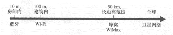
This section introduces current hot technologies such as mobile computing, wireless transmission, and mobile positioning, which are the foundation of mobile GIS. Mobile devices can be divided into five categories: mobile phones (including simple mobile phones and smartphones), palmtop computers, tablets, laptops and other special devices (Figure 5. 3)。 Mobile phones: This is the most common mobile device and includes mobile phones (connected to a cellular communications network) and satellite phones (connected to a satellite). Simple mobile phones only have calling and text messaging functions, and have limited storage and computing capabilities. Smartphones have stronger configurations and also support web browsing, email, downloading and installing software Software application, data loading and other functions. In addition, mobile phones are already widely equipped with accessories such as Bluetooth, camera, camera and GPS. Pocket computers: Also known as r*DA( personal digital assistants ), such devices and mobile phones are constantly integrating, and many smartphones have the function of personal digital assistants. Pocket computers don’t necessarily have calling capabilities, such as Apple’s iPod Touch, which can access the Internet via Wi-Fi without having to pay for phone and Internet traffic, and have a sizable user base. Tablet PC: The emergence of Apple’s iPad, with its fashionable appearance and excellent user experience, has led the trend of tablet computers and driven the popularity of many tablet products. Tablet computers have a larger screen than mobile phones and are rich in expression. They are a mobile GIS platform with great potential. Tablets do not have a calling function, but most of them can access the Internet via Wi-Fi, and some can also access the Internet via cellular communication networks. Portable computers (portable computers): Portable computers have powerful processors and large storage capacity, and can provide the running environment required by desktop GIS software. However, they are heavier than other mobile devices, are less mobile, and often need to be fixed in vehicles. Special equipment: Including equipment equipped with cured or embedded applications, including in-vehicle GPS navigation systems, etc. Like desktop computers, mobile devices have a mobile operating system. The mobile operating system determines the functions that mobile devices can provide and controls the touch screen, keyboard, wireless connections, etc. on the device. Common mobile operating systems include Google’s Android, Apple’s iOS, Microsoft’s Windows Phone and Windows Mobile, Hesse’s RIM, and Nokia’s Symbian. However, these systems are not compatible, which also poses challenges to mobile GIS application development, so native applications on one operating system often cannot run on other operating systems. If you adopt the local application development method (see Section 5. Section 3), developers often need to determine the one or more operating systems to target based on the user groups they target, and use different technologies for application development for each operating system. Different communication technologies differ in terms of data transmission speed, transmission distance, construction cost and scope of application (Figure 5. 4), Each technology also has multiple specifications. For ease of discussion, this section discusses typical performance parameters of these technologies. Fig. 57 Wireless communication technology and effective range # Bluetooth The name “Bluetooth” comes from Harold Bluetooth, King of Denmark. It is a mobile communication technology that covers a range of about 10 meters. Bluetooth applications mainly include communication between mobile devices and their affiliated devices, such as the connection between mobile devices and headphones and microphones. Wi-Fi(wireless fidelity) A single Wi-Fi router can cover a range of about 100 meters, with data transmission speeds of 10 to 54Mbps. Wi-Fi is generally used to build wireless local area network suitable for homes, companies and college campuses. Wi-Fi networks are available in public areas such as libraries, airports, train stations and cafes in some countries, and these areas are known as “Wi-H hotspots.” cellular network A cellular network is a communication network composed of many wireless cells, each cell being wirelessly connected to at least one base station (i.e., a mobile transceiver tower). Numerous base stations form a mobile wireless network covering a wide area. Different wireless communication providers and government departments have built different cellular communication networks. The communication distance of a base station can reach 50 kilometers, but in practical applications, the density of the base station and the coverage of cellular signals need to consider the frequency, terrain, user density and dynamic changes used in wireless communication. Cellular network communication technology has evolved over multiple generations. 1G: The first-generation wireless communication technology based on analog signals can only transmit voice and does not support GIS application. 2G and 2.5G: The second-generation wireless communication technology based on digital cellular networks can support voice and data transmission capabilities of around 10Kbps. 2. 5G is between 2G and 3G, and the data transmission speed can reach 384. Kbps。Developing mobile GIS on 2G and 2.5G networks is limited by low data transfer rates. 3G: The third-generation mobile communication technology can provide data transmission speeds of up to 2 Mbps and a series of advanced services, including Web browsing and online video viewing. With the support of 3G technology, mobile Dynamic GIS applications can provide a relatively smooth user experience. 4G: The fourth-generation mobile communication technology can theoretically provide data transmission speeds of up to 100 Mbps, which can promote the further vigorous development of mobile GIS. The 4G network can adopt LTE (long-term evolution), WiMAX( Worldwide Interoperability for Microwave Access), or UMB(Ultm Mobile) Broadband (Ultra Mobile Broadband) and other technologies. Positioning capabilities are the cornerstone of mobile GIS, which is important for applications such as location-based services and emergency response. Especially important. There is an example: In 2001, a woman in Florida, USA, ran into a canal on the roadside due to her car losing control. She used her mobile phone to contact rescue workers, but the rescue time was delayed because she could not describe her exact location. Finally, rescue workers found and fished out her car, she was already unfortunately killed (Popular Science, 2002). The U.S. government has long realized that a large number of emergency calls for help in the future will be made through mobile phones, and this trend is growing rapidly. Therefore, as early as 1996, it passed bills such as “Improvement 911”, requiring mobile phone operators to gradually improve positioning capabilities in the following years, so that government emergency departments can determine the location of the person who needs help when receiving a call for help. In addition, similar laws have been enacted in Europe, which have promoted the development of mobile positioning technology. Today’s mobile positioning technologies mainly include positioning methods based on navigation satellites, cellular communication networks, Wi-Fi networks, IP addresses, and RFID(radio frequency identification) technologies. Navigation satellite-based methods The Global Navigation Satellite System (GNSS) allows electronic receivers to determine their position through satellite signals. The most commonly used positioning satellite system is the United States ‘GPS, in addition to China’s BeiDmi, Russia’s GLONASS and the Galileo system under construction in the European Union. Satellite positioning technology requires mobile devices to have built-in or external satellite receivers. The advantages of this technology Points are high positioning accuracy. Under clear skies, no obstruction, and good satellite distribution, the horizontal positioning accuracy of GPS can reach below 5 m (KoWoma, 2009), and can be accurate to below 1m through real-time differential correction. This technology is often used in applications that require high positioning accuracy, such as outdoor measurement, vehicle navigation and equipment maintenance. However, this technology requires mobile devices and satellites to be able to look directly at the line of sight, so in rooms, tall buildings, or other objects, the positioning accuracy may be reduced or even impossible to locate at all. Cellular network-based positioning method Such methods locate based on the relative positions of mobile devices such as cellular base stations and mobile phones. This method has lower positioning accuracy than satellite positioning, but it does not require a direct line like GPS. It can still locate even in rooms and tall buildings. There are many ways to implement positioning methods based on cellular networks. The most basic is the “cell of origin”(COO) method, which takes the location of the base station receiving tower of the cell where the mobile device is located as the location of the mobile device. This method is low-investment, but the positioning accuracy depends on the range of the cellular network, reaching hundreds of meters in urban areas with high base station density and thousands of meters in remote mountainous areas with low base station density. Other methods include signal “time of arrival”(T0A),”time difference of arrival”(TD0A),”angle of arrival”(A0A), and “enhanced observed time difference location technology”(E-0TD). These technologies use cellular network triangulation methods to achieve positioning accuracy within 100 meters, but often require directional antennas and high-precision timing equipment, so the investment is high. Assisted GPS positioning method Assisted GPS positioning method (A-GPS) combines both satellite and cellular positioning technologies to maintain high positioning accuracy and can still position even in areas affected by obstacles. Wi-Fi based positioning method When a mobile device connects to the Internet via Wi-Fi, its location can be estimated from the location of Wi-K hotspots. This approach relies on the Wi-Fi hotspot database and takes advantage of the technical parameter that Wi-Fi devices are typically within 100 meters of hotspots. In addition, the positioning accuracy can be further improved through triangulation of hot spots. Positioning method based on IP address After a mobile device is connected to the Internet, its IP address can also be used to determine the location of the device. However, since computers in many units share an external IP address, the positioning accuracy of this method is relatively low, and can generally reach the spatial accuracy of the municipal or district level. People want mobile devices to be as small and light as possible for easy portability. However, portability comes at a cost. Due to the limitations of size and quality, mobile devices sacrifice in terms of CPU (central processing unit) speed, data storage space, network connection, screen size and standby time. Therefore, when designing mobile GIS applications, The impact of the following factors needs to be fully considered: Limited system resources (CPU, memory and battery) The system resources of mobile devices are relatively limited, so mobile GIS software needs to be streamlined and efficient as possible. Complex analysis and calculations should be distributed on the server side as much as possible, and the data that needs to be preloaded should be streamlined as much as possible, such as deleting useless fields and performing cartographic synthesis. Data collected by mobile devices needs to be synchronized to the server in a timely manner to avoid data loss due to unexpected conditions of the device. Limited network bandwidth and intermittent network connections Wireless communication services are affected by many conditions, such as weather conditions, surrounding environment, and distance from base stations, so the actual wireless network speed will be lower than the theoretical speed, and in some areas there may be no wireless network connection. Mobile GIS systems need to minimize the amount of network data transmission. For projects that require work offline, mobile GIS systems need to load data into the device in advance. Small screen and keyboard, complex outdoor environment Factors such as limited screens and small keyboards pose challenges to interface design for mobile GIS applications. Some mobile devices use touch screens, but the operation accuracy of human fingers is low and not as accurate as the mouse on a desktop computer. The user interface of mobile GIS needs to be determined based on outdoor work and workflow. Obviously, designers should not move the user interface of desktop software directly to mobile devices, but need to consider making reasonable designs based on the hardware resources of the device. Avoid filling the screen with a large number of toolbars and menus, use options as much as possible to replace or reduce text input, and try to use bold fonts, high-contrast colors, and simple symbols. During the day, the brightness and contrast of the user interface and map are high in strong sunshine; at night, the brightness of the user interface is low. Use the current location of your mobile device as much as possible to assist map navigation and information search. The direction of desktop maps is generally fixed, mostly from top to bottom to bottom. For mobile GIS applications such as navigation, the top of the map should point to the movement direction of the user’s vehicle, and consider 3D(or 2. 5D) map display method. Mobile applications can also consider using voice prompts, such as Siri, the voice control system of the iPhone 4S, which has high intelligence and provides a new and convenient way of human-computer interaction. As technology develops, some limitations will gradually be overcome or improved. For example, the computing power of a smartphone today is more powerful than the mainframe computers used in the U.S. Moon landing program in the 1960s. Although mobile platforms pose some challenges to the application development of GIS, mobile platforms have many irreplaceable advantages and are developing rapidly. Its multi-touch screen and voice control performance are natural and convenient, suitable for all ages. Many people love it and will become more and more popular. It will become increasingly popular and popular, and will become an increasingly important client of WebGIS.mobile device #
wireless communication #
mobile Positioning technology #
technical challenges #