Information sharing is an important part of NSDI #
Spatial data infrastructure (SDI)-The term first appeared in the National Research Council’s article “Creating a Coordinated National Spatial Data Infrastructure” in 1993 and in the 1994 Presidential Order No. 12906 of then-President Bill Clinton on “Building NSDI in the United States”, in which NDSI is defined as the technology necessary to acquire, process, store, share, distribute and make full use of geospatial data. A general term for policies, standards, and human resources (Figure 7.1). From the perspective of information science, data is the source and carrier of information, so people often regard NSDI and NSII General Motors (Wu and Tong, 2008). Fig. 82 Various components of NSDI collaborate with each other to promote geospatial information sharing # 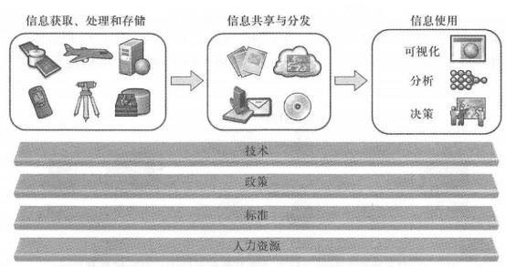
One of the most important tasks and purposes of NSDI is to promote the sharing of geospatial information among governments, enterprises, science and education, other institutions and the public at all levels. Geographical data has basic characteristics such as distribution, regional differences, and high collection costs. People often cannot find all the information they need in a single database or in a single data format. GIS users often need data resources collected or owned by other organizations, so “collect once, use multiple times” has become one of the main principles advocated by NSDI. The traditional geographical data sharing methods are data copying and map printing. This method is still needed in many cases, but its limitations are becoming more and more obvious, and people are increasingly demanding Web service-centered sharing methods (Figure 7.2). Fig. 83 Geographical information can be shared in many ways, among which Web service-based sharing methods have many advantages and are gradually becoming popular # 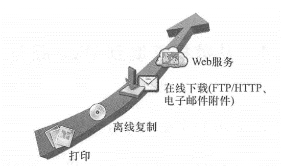
NSDI 1.0 based on data replication #
Traditionally, departments that require GIS often have to purchase GIS hardware and software, equip professional GIS personnel, and purchase copies of geographical data. As shown in Figure 7.3, data providers need to export the data into a specific format, burn it on tape or optical disk (such as CD-ROM or DVD), and ultimately distribute the data to other institutions via post office or electronic transmission (such as FTP, HTTP, or email). After users receive the data, they need to load it into the database and sometimes perform data format conversion before building their application. Fig. 84 Sharing methods based on data replication involve the export, transportation, conversion and import of data, and often have low effectiveness and efficiency # 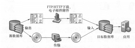
Although this data-replication-based approach is still needed in some situations, it has the following disadvantages:
Delay: The process of exporting, mailing, downloading, and transferring data is time-consuming and generally takes hours or even days. During this period, the data source may have been updated and the copy received by the user may have become outdated. Traditional data replication methods are inadequate for rapidly changing situations such as emergencies and applications that require high effectiveness such as Incident Response Service (Zhao, Yu, and Di, 2007).
Higher receiving costs: The receiving unit needs to have appropriate hardware, software and professional employees to transfer data and optimize the database. These costs are usually more expensive for non-professional GIS units or smaller units. In some cases, such as images that often reach terabytes, copying and transferring the entire database is often impractical.
Copyright issues: Once the data is copied by other departments, the source data owner loses control of the data. Many units that own data may be reluctant to share their data due to concerns about losing intellectual property rights.
The above-mentioned shortcomings of data replication have become increasingly obvious, making it difficult to meet the needs of today’s society for data and GIS. For example, emergency management needs to integrate real-time data from multiple departments to make timely decisions. Their needs for geographical information are highly time-sensitive; restaurant owners need to choose the most favorable location to open restaurants, but they often do not have any GIS concepts and software and hardware. In addition, duplicate data copying or purchasing between units often leads to duplicate work and waste of funds. For these reasons, NSDI requires a better way to share data (Birms,2007).
NSDI 2.0 based on Web services #
The latest developments in World Wide Web technology have provided new technologies for information sharing, such as Web services, service-oriented architecture (SOA), aggregation, cloud computing, and user-generated content (UGC). Web services and aggregation are covered in Chapters 3 and 4, which will discuss SOA, UGC, and cloud GIS.
Just as children use blocks to build a house or car, professionals use software components to build information systems. The concept and technology of software components have a long history and are constantly evolving (Figure 7.4). As early as the 1960s, people used functions and subroutines as building blocks of software development. By the 1990s, developers began to adopt object-oriented programming, in which “objects” are like building blocks. Later, the concept of service-oriented architecture was introduced (Schulte and Natis, 1996). S0A is a software architecture style that packages business functions into loosely coupled, distributed services or units that can be easily reused and combined to build new software applications. In S0A,”services” are building blocks. The granularity of services is larger than that of previous software components. They are coarse-grained components. The advantage of this is that they are faster when building applications. S0A advocates a loosely coupled reorganization approach to Fig. 85 With the development of information technology, software development components are also constantly enriched # 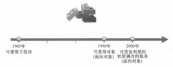
Achieve flexibility in reorganization and deployment. Web services, especially REST-style Web services, are coarse-grained, loosely coupled, and easy to use, making them an ideal way to implement SOA. Some people also call SOA based on RESTful Web services WOA( Web-oriented architecture)(Thies and Vos-sen,2008). It can fully leverage the advantages of the Web and the implementation method is easier and cheaper than other SOAs (Hinchcliffe, 2008;Gall, 2008;Kralidis, 2007). S0A provides a Web service-based sharing approach that in most cases has more advantages than data replication.
Reduce costs: Users based on Web services can use multiple services for free or pay based on actual usage without having to purchase and install some GIS software and hardware locally to transfer human data.
Greater data availability: When the source database is updated, these updates are reflected on the Web service for use by all customers.
Greater flexibility and agility: You can take full advantage of the World Wide Web and dynamically combine multiple services through non-programming (such as geo-browsers) or simple programming methods, which reduces the difficulty of reusing geospatial data and functions.
Better protect intellectual property rights:Web service providers still control their information and can protect their intellectual property rights through free, password protection, and fees.
Because of these advantages, many people have put forward suggestions to create a new generation of NSDI based on Web services. For example, Lisa Campbell and others of Autodesk Company in the United States (2009) emphasized the importance of S0A to NSDI in their proposal “Revitalizing the U.S. Economy by Investing in NSDI”:”NSDI integrates multiple sources of information and uses standard protocols (particularly in line with the architecture of Web services oriented to the OGC specification) so that geospatial data can be coordinated and integrated into a common framework that can support multiple functions of government at all levels and multiple needs of commercial activities. Jack Dangermond and others of Esri Company in the United States (2009) said in their proposal “Investing in Geospatial Information Infrastructure-Building a National GIS”:”Modern GIS server technology, as well as open standards and service-oriented architecture, have been able to support the construction of national GIS. Dangermond advocated a shift from file sharing to geospatial services in an interview with Government Computer News (Kash,2009):”The approach to building a comprehensive geospatial framework is not to put all data into one huge database, but to create a series of distributed geospatial Web services that can be dynamically combined through open standards and free programming interfaces to support visualization, querying, and support advanced applications.”
NSDI 1.0 is government-centered, with the government as the main data collector, provider and user, and the new generation of NSDI needs to integrate richer information, including voluntary geographical information (VGI; see Section 10.1). Phenomena such as crowdsourcing and Social networks that have emerged in recent years have created a large number of UGCs and formed a bottom-up flow of information. VGI refers to content related to geographical location created by users. This information can be collected and organized, published and reused in the form of Web services, etc., which will greatly expand and enrich the data content of NSDI, and will also encourage the participation of the public and other institutions.
Cloud computing technology is developing rapidly. The combination with GIS is called cloud GIS. It can be used as a hosting platform for Web services and a development platform for building WebGIS applications (see paragraph 10. 1.8)。The advantages of cloud GIS are gradually recognized and accepted by people, and are actively adopted by major companies and some government agencies. It will become an important infrastructure for the new generation of NSDI.