basic concepts #
“portal”-The word comes from Latin and refers to population or gate. Webportals, also known as search engines, are entrances to information on the World Wide Web. They can help users search for the information they need among the vast amount of information on the Internet. Since the mid-1990s, the amount of information on the Internet has exploded, and people urgently need a tool to quickly find the content they need in this huge amount of information. Portal sites such as Google, Microsoft Bing, Yahoo and Baidu meet this need, indexing and organizing information on the World Wide Web. Using these portals, people can quickly find relevant websites from hundreds of millions of web pages by inputting one or more keywords. Portal websites help the World Wide Web avoid the disorderly dilemma of trapping people in massive amounts of data and have played an important role in the success and popularity of the World Wide Web (Tang and Selwood, 2005).
As the name suggests, Geoportal is a website that helps people find and discover geospatial information (Tait, 2005) , which facilitates communication between geospatial information providers and users. The provider publishes geographical metadata, and the user searches in the geographical information portal, and obtains the geographical information they need by downloading online, connecting to Web services, or contacting the data provider (Figure 6.1). The Alexandria Digital Library (Smith and Frew, 1995; Goodchild, 2004) and the National Geospatial Data Clearinghouse (NGDC) are early examples of geographical information portal applications. Fig. 68 Geographic information portals provide a channel between geographical information resource providers and users # 
The facade of geospatial information infrastructure #
Geographical information is an important basis for the government to make social, economic and environmental decisions. Governments need complete and detailed information to support decision-making. However, many departments lack the mechanism and motivation to share information and are unable or unwilling to share their data, thus forming many information islands, resulting in insufficient utilization of geographical data, repeated data collection, waste of funds, time delays and insufficient decision-making information.(Sun Jiulin and Shi Huizhong, 2002; Wang Juanle, 2005). The concept of spatial data infrastructure (SDI; see Chapter 7) was proposed to solve this problem. SDI is the technology, policy, standard and necessary human resource foundation for acquiring, processing, storing, distributing and promoting the use of geospatial data. One of its purposes is to maximize the use of geospatial information owned by each unit.
Geographic information portals aim to promote cooperation and achieve sharing and are an important part of SDI. Without a geographic information portal, it may take a department days or months to learn about the data held by other agencies through phone calls, letters, emails, and even on-site consultations. With geographical information portals, the time needed to search for this information can be shortened to just a few minutes. As an intermediary between data providers and users, geographic information portals are the most visible part of SDI and are therefore known as the “facade” of SDI (Tang and Selwood 2005; Hogeweg 2009a). In the past decade or so, most countries around the world have carried out SDI construction (MaSSer, 2007; Li,2006; Maguireand Longley, 2005). International organizations such as the Global Spatial Data Infrastructure Association (GSDIA ) and the Group on Earth Observations (GE0) are working hard to promote the development of global spatial data infrastructure. GSDIA has launched a guide to the construction of spatial data infrastructure (Nebert, 2004) to guide SDI construction around the world.
The construction of SDI in the United States began early, with the establishment of the Federal Geographical Data Commission (FGDC) in 1990, which includes the U.S. Geological Survey (USGS) and other major federal agencies related to geographical information. The goal of the FGDC is to coordinate and promote the collection, utilization, sharing and dissemination of spatial data across the country.
In the mid-1990s, FGDC and USGS presided over the establishment of NGDC, which was once a major geographic information portal in the United States and one of NSDI’s significant success stories.
In 2003, as one of the 24 e-government projects of then-President Bush, the Geospatial One-Stop (G0S; http://www_geodata.gov ) (Figure 6.2) was put into use. It replaced NGDC and became the main gateway for geographical information in the United States.
In 2009, as part of then-President Obama’s “Open Government Plan”, the United States established a new geographical information portal,”Data,gov”. Its geographical information retrieval function calls G0S’s database and the metadata service interface it provides. In September 2011, the geographical data part of data, gov was integrated with G0S, replacing G0S and becoming the main portal for geographical information in the United States (geo.data, gov).
The United States has also built many thematic and regional geographic information portals, such as NASA’s Global Change Master Catalog (GCMD; http://gcmd.nasa.gov ), Arkansas Geographic Information Warehouse, Kentucky Watershed Model Information Portal (KWMIP), and Mississippi Geographic Information Portal.
GIS vendors have also launched portal software products, such as the Geography Network launched by ESRI in 2000 and Geoportal Server launched in 2003. In recent years, ArcGIS.com, the portal website of Esri ArcGISOnline cloud GIS, has attracted the attention of many government agencies with its dynamic query and composite Web services. Esri uses ArcGIS. Based on com, launched
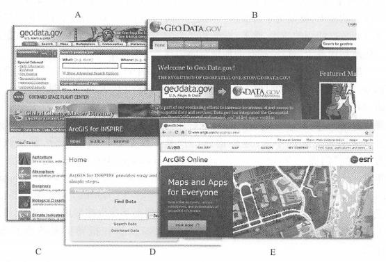
Fig. 69 Examples of geographical information portals: (A) the one-stop portal for geographical information in the United States (merged with B);(B)Geo.data,gov; (C) NASA’s Global Change Master Catalog;(D)Esri’s portal for EU geospatial data infrastructure;(E)ArcGIS Online’s portal (i.e., ArcGIS Portal) #
ArcGIS Portal(also known as Portal for ArcGIS) is a portal product that is adopted by multiple departments of the U.S. federal government.
The European Union (referred to as “EU”) in the form of an order requires member states to join forces to establish the European Geospatial Information Infrastructure (INSPIRE). One of the important tasks is to establish a geographical information portal. This is probably one of the most complex portal projects, as it must address differences in data integration, business processes, language and culture among member states. The GeoConnections Canada project is part of Canada’s Geographical Data Infrastructure (CGDI), and its geographical information portal is dedicated to helping users share geographical information in four priority areas: public security, public health, residential community services, environment and sustainable development. The Australia and New Zealand Land Information Commission (ANZLIC) coordinate the construction of spatial data infrastructure and established the Australia Spatial Data Catalog, a geographical information portal.
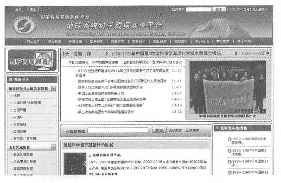
In China, institutions such as the National Geospatial Information Coordination Committee (NGICC) and the National Basic Geographic Information Center are leading and coordinating the construction of SDI. The Ministry of Science and Technology successively launched several data sharing pilot projects in 2001, and began to build a national science and technology infrastructure platform in 2003. The Earth System Science Data Sharing Platform ( http://www.geodata.cn ) is a representative platform in the field of scientific data sharing (Figure 6. 3), provides the public with rich geographical information and earth system science related data. Fig. 70 Earth System Science Data Sharing Platform Home #